
 List
List Abstract
 One+Abstract

| Mongolia Group Panorama | |
| Resolution: 21595 x 2206 | |
Here’s my now-obligatory group panorama for the 2025 Mongolia trip.
From the left: Vince, Oyu, Mike, Yours Truly, Denise, Marco, Bayar, Ebu, Yasmin, Ann, Lee, Sarah, Christian, Steph


| Mongolia Group Panorama | |
| Resolution: 21595 x 2206 | |
Here’s my now-obligatory group panorama for the 2025 Mongolia trip.
From the left: Vince, Oyu, Mike, Yours Truly, Denise, Marco, Bayar, Ebu, Yasmin, Ann, Lee, Sarah, Christian, Steph
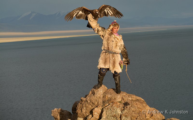
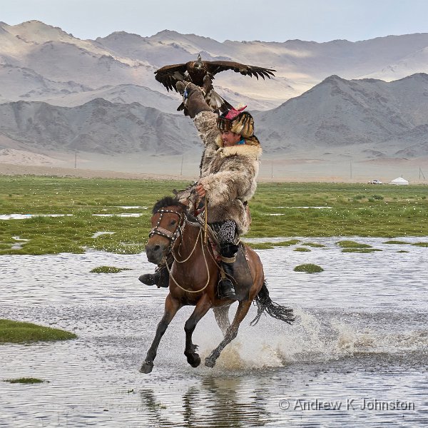
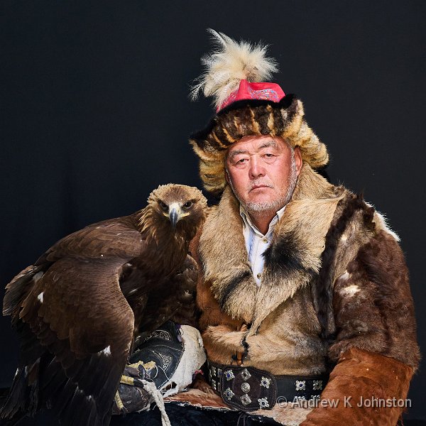
| Eagle hunter at Tolbo Nuur | |
| Camera: Panasonic DC-G9M2 | Date: 01-08-2025 19:36 | Resolution: 5299 x 3312 | ISO: 100 | Exp. bias: -33/100 EV | Exp. Time: 1/160s | Aperture: 5.6 | Focal Length: 57.0mm (~134.0mm) | Location: Tolbo Nuur | State/Province: Chzhirgalantu-Sagsay-Somon, Baya | See map | Lens: LUMIX G VARIO 35-100/F2.8II | |
Friday starts with another late breakfast. One could get used to this. The group then divides, several electing to stay around the hotel for the morning, but I join a group who go across town to a viewpoint which is a good location for both still and drone photography.
Lee and Yasmin both fly their DJI Mavic drones, which are almost large enough to need a freight licence. They unpack them onto the mats, press “take off” and go. I launch my diminutive Mini 3 Pro, the size of a couple of packs of cigarettes, hoping for a similar low-friction experience, but no, I am apparently too close to the airport and need special permission!
Ebu, our guide who is a drone specialist, takes one look at the controller screen and just shakes his head, but he has reckoned without Andrew’s “dog with a bone” approach to being told something is not possible. It is an arcane process. I have to launch the drone and have it hovering to trigger the process, then I have to connect the controller to WiFi to fill in the registration, then I have to get a text on my phone, then I have to land the drone and disconnect WiFi for the authorisation to complete. By this time the drone’s battery is almost empty so I swap it out, take off and get the warning again, and have to repeat about 80% of the process…
To paraphrase Those Magnificent Men In Their Flying Machines: “Up, Down, No flying around…”
It is all worth the effort as Ebu then gives me a lesson on drone flying and I learn a few useful techniques. I get a couple of nice panoramas of the city, but in terms of the classic “pretty roofs” shot I think I prefer my shots from the incoming plane flight. Oh well.
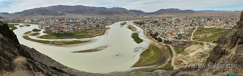
| Ulgii panorama (Show Details) |
| Flying into Ulgii Airport (Show Details) |
Lunch is at a Turkish restaurant. They don’t have beer. Fair enough, maybe they are Muslims. But then we work down the drinks list, and discover neither do they have coke, fresh-brewed tea, or bottled water! There’s no explanation, and we just end up sending one of the drivers out for water and coke. Very odd.
I opt to walk back from the restaurant to the hotel via the main shopping square, but it’s not a great success. I do find one shop with “tourist” T-shirts but they are all ghastly, horrible designs and not good quality. I may have to manufacture my own.
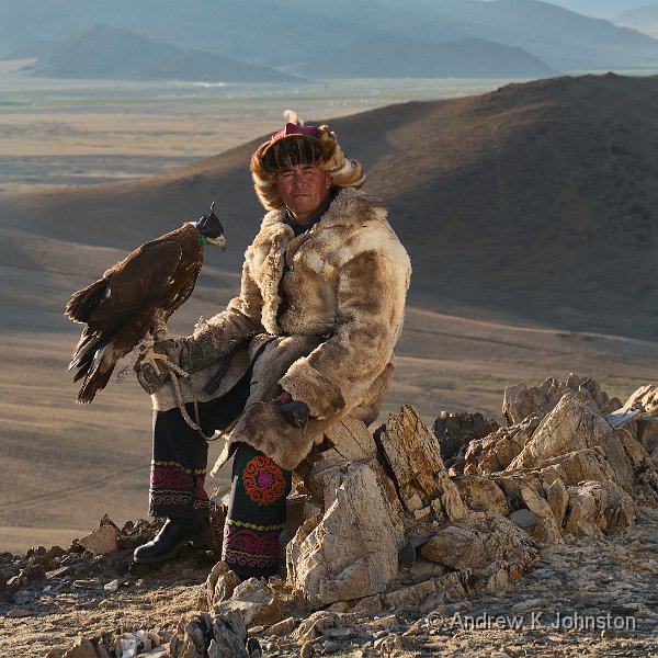
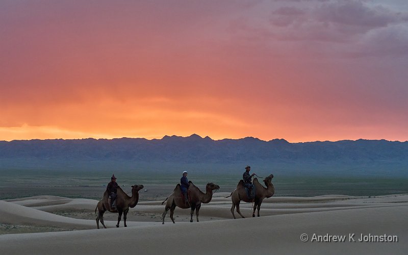
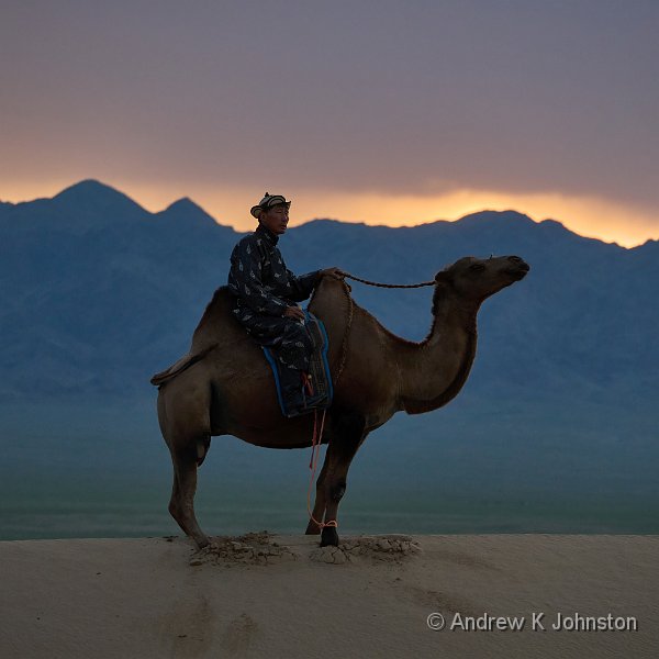
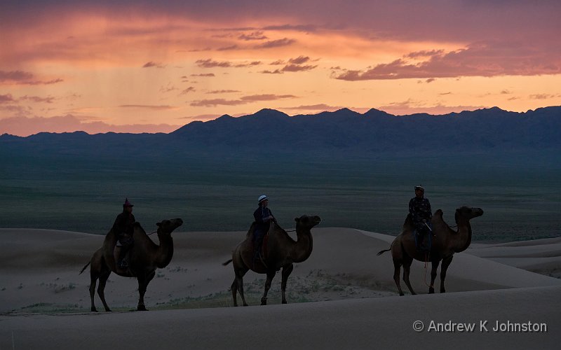
From the hotel we head south of Ulgii on a good paved road which takes us almost the whole way to a pretty lake surrounded by mountains, Lake Tolbo. There we are joined again by several of the first group of eagle hunters, who do a bit more “riding dramatically through the water”, and then we all climb a rocky outcrop to get photos of them in evening light with the dramatic scenery behind them.
| Eagle hunter at Tolbo Nuur (Show Details) |
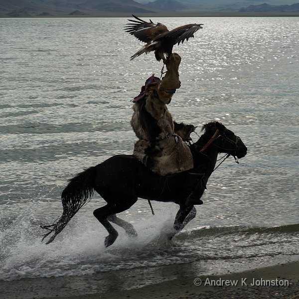
| Eagle hunter at Tolbo Nuur (Show Details) |
We watch a dramatic sunset, then head back on the relatively short drive to town.
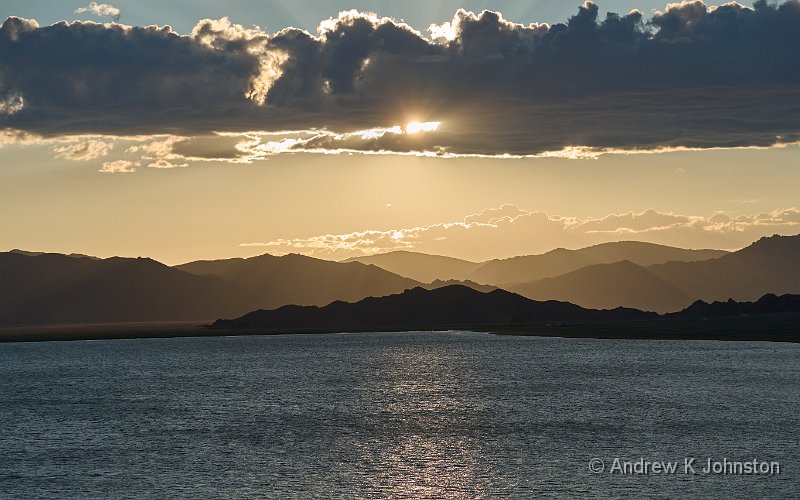
| Tolbo Nuur (Show Details) |
At a different restaurant we hear a familiar refrain. No wine or beer, and we’re not allowed to bring any in. Apparently the local administration has decided that to fit with Muslim sensitivities Friday should be “dry”, alcohol free, like Sundays in Wales when I were a lad.
That’s fair enough, but things seem to have spiralled out of control and again we’re told they are now out of soft drinks and water. One of our drivers does the necessary, but this does seem like an odd consequence of the legislation. Either the restaurants are over-interpreting the rules as “no drinks”, or they are not managing things very well. Surely Friday arrives on a sufficiently predictable schedule that they could stock up?
Dinner is very tasty, but takes a long time to arrive, especially Yasmin’s pizza. That’s so late that it doesn’t all disappear, and I snaffle a couple of slices as an alternative to the execrable hotel breakfast. Back at the hotel I discover one last can of beer and head for the terrace, but sadly comms are down and no-one joins me. However it’s still a nice way to bid farewell to Ulgii.
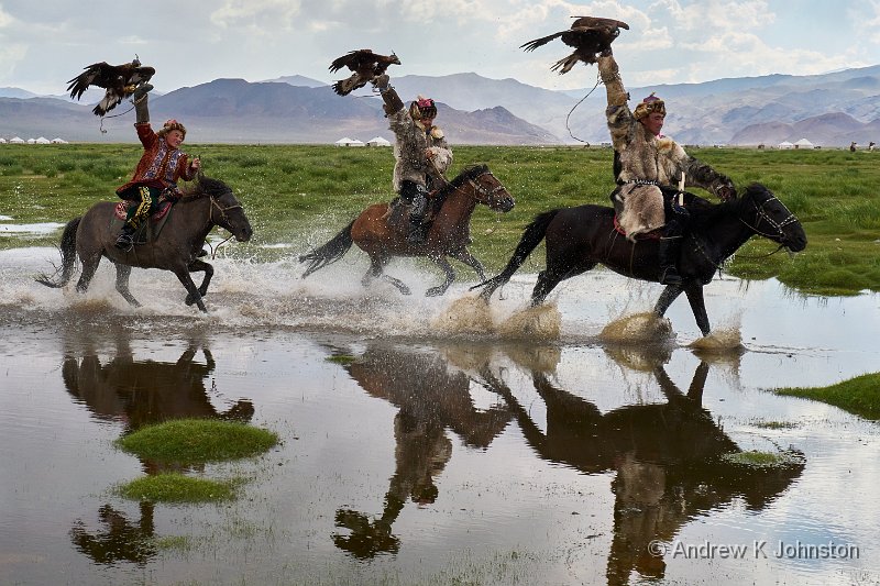
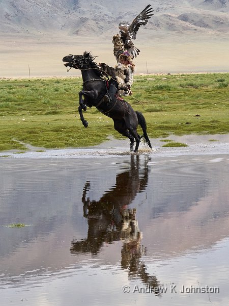
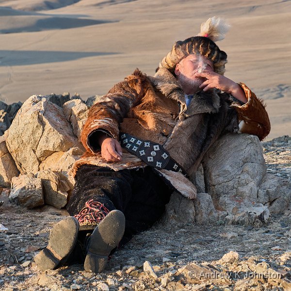
| Eagle hunting festival | |
| Camera: Panasonic DC-G9M2 | Date: 31-07-2025 16:11 | Resolution: 5862 x 3908 | ISO: 800 | Exp. bias: 0 EV | Exp. Time: 1/400s | Aperture: 14.0 | Focal Length: 35.0mm (~70.0mm) | Location: Sagsay sum | State/Province: Uujim, Bayan-�lgii Province | See map | Lens: LUMIX G VARIO 35-100/F2.8II | |
Lee must be losing his grip. We have a morning off! Most of us lie in for a late breakfast around 9, then spend the morning pottering. I walk out to try and find some shops, but completely miss the main square although it’s only a few streets away. I do find one souvenir shop with very nice T-shirts, high quality with an attractive and properly printed design, but they only have them in small!
The services of the Makhsum Centre Hotel are, to be polite, a bit dodgy. Their breakfast has to be among the worst I have ever experienced, with bread which could be used as a construction material, and the two pairs of trousers I send to the laundry come back inside-out and rolled into a tight ball. The laundry ladies at the Heure Bleue Palais in Essaouira who not only pressed my underwear but put each pair into its own separate packet don’t have to worry about the competition.
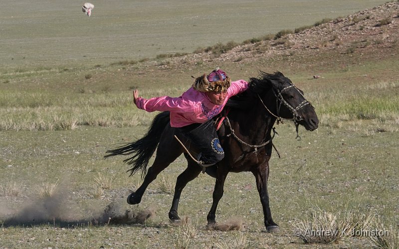
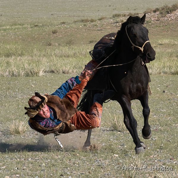
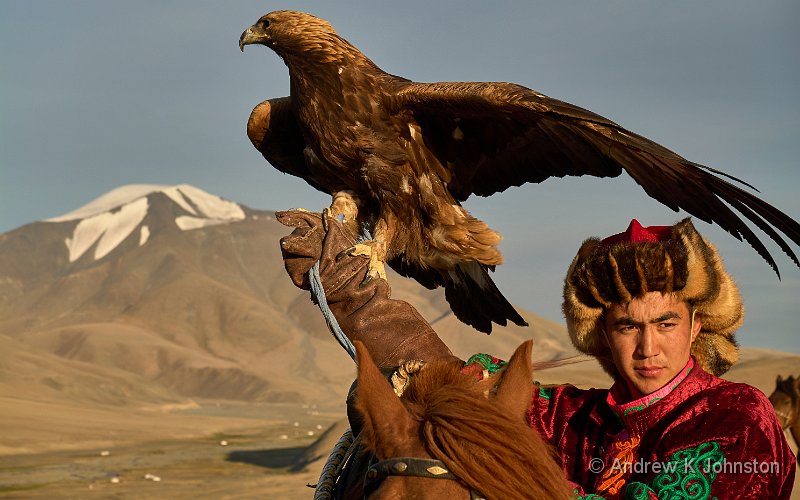
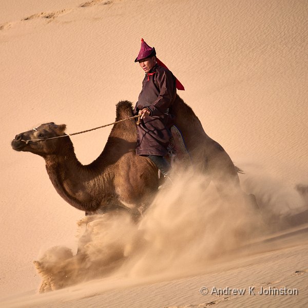
After lunch we head up into the hills for our own private eagle hunting festival. This is a long-standing Kazakh tradition, in which the hunters tests the relative skills of themselves, their horses and their eagles through a series of events.
We do seem to have added one new event to the traditional set. First we meet up with some of the participants who engage in the new sport of "riding your horse with eagle through water for foreign photographers". All score well, but there is an active debate between the participants with cameras about positioning. First discussion is about choice of background, whether to have cows or gers in the background. We end up singing "Cows to the left of me, Gers to the right, here I am stuck in the middle with you!"
| Eagle hunting festival (Show Details) |
There’s also the question of how to frame the action. Most of the others are obsessed with getting a head-on shot, but I also revert to the sideways panning approach honed from polo and horse-boarding and get some great variations.
| Eagle hunting festival (Show Details) |
Up the hill, the festival is opened as traditional with a song, but we forgo the poetry competition, Just as well as I’m starting to wonder if we’re supposed to contribute, and if so how well "There was a young lady from Bude" will translate.
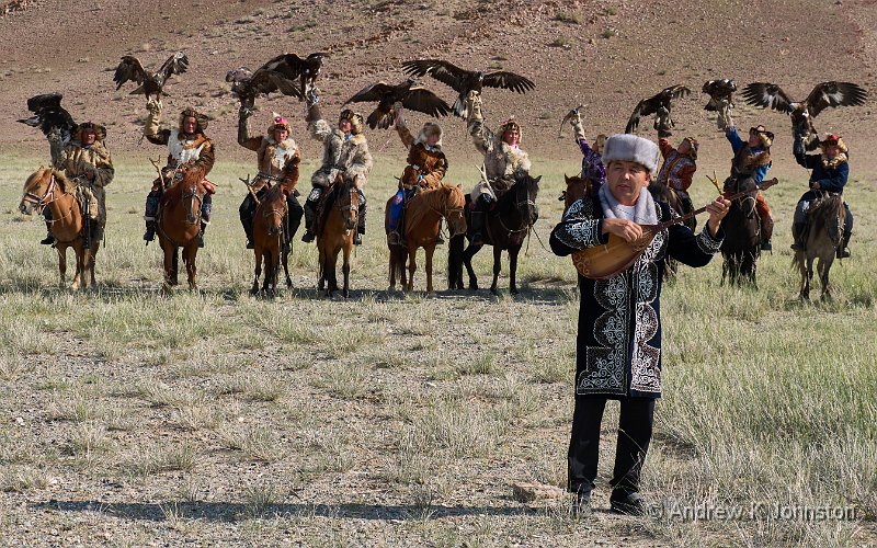
| Eagle hunting festival opening ceremony (Show Details) |
The first events are tests of the eagles, timing them flying from the top of the nearest ridge to their master’s hand, and then to a moving lure towed behind the horse. The only slight problem is that this early in the season most of the eagles are too well fed, and the group only have one who’s in the right state of hunger. However after performing 3 times and getting 3 treats she is also well fed and visibly getting a bit bored.
| Eagle hunting festival (Show Details) |
The other sports challenge the horses and riders, and are better populated. They include a form of horse-borne tug of war, and a competition to pick up small bags of money while galloping past them at speed. Both competitions are won by the reigning local champion, a handsome chap in a pink shirt channelling a cross between Jason Momoa as Khal Drogo in Game of Thrones, and Oded Fehr as Ardeth Bay in The Mummy. Predictably the ladies all go gooey.
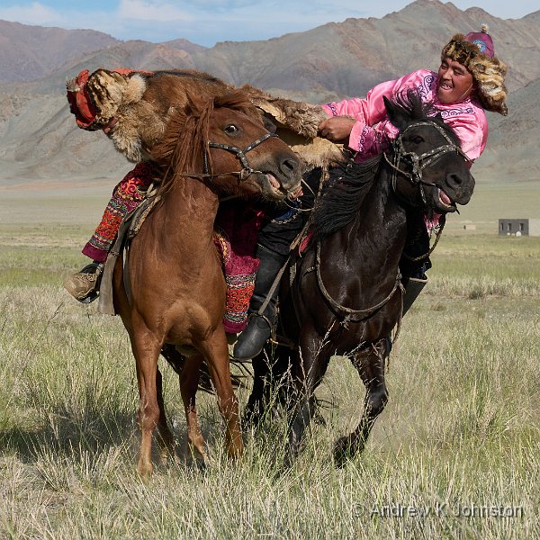
| Eagle hunting festival – tug of war (Show Details) |
| Eagle huting festival – picking up money (Show Details) |
We engineer a further break with tradition by doing a whip-round and sending one of the drivers off to the village for beer. Excellent addition.
The eagle hunting festival may very well be the most intensive single shoot I’ve ever done. I captured 1330 images, around 57GB, but several of the team who left their cameras on high-speed mode are up at three or four times that number.
| Eagle huting festival – picking up money (Show Details) |
Once the sport is complete we have a series of portrait sessions, taking maximum advantage of the evening light, then it’s back to Ulgii for a late dinner. This is followed by a rather pleasant nightcap on the hotel’s roof terrace, using up the spare beer, plus a couple of bottles of wine for the ladies. Good day.
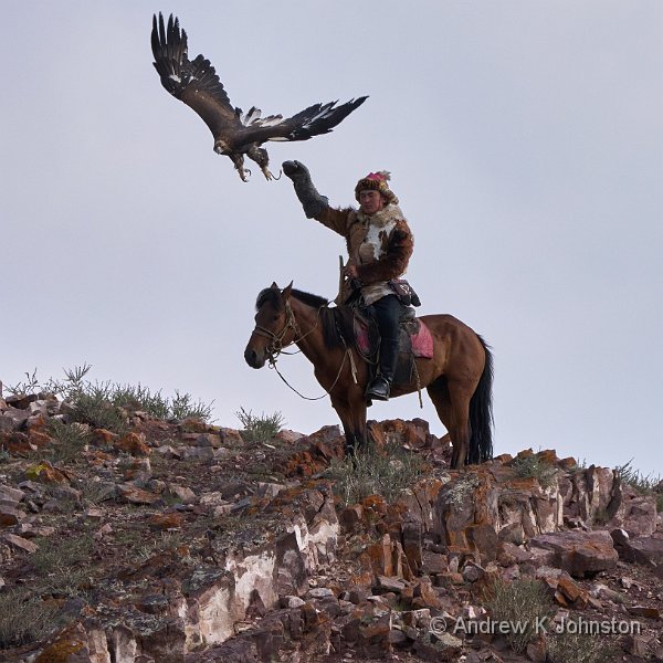
| Eagle Hunter in front of Mount Tsambagarav | |
| Camera: Panasonic DC-G9M2 | Date: 30-07-2025 15:51 | Resolution: 5776 x 3610 | ISO: 100 | Exp. bias: -33/100 EV | Exp. Time: 1/250s | Aperture: 7.1 | Focal Length: 31.0mm (~62.0mm) | Location: Erget Gol | State/Province: Tsagaantüngi, Bayan-Ölgii Prov | See map | Lens: LUMIX G VARIO 12-35/F2.8II | |
We’re up before 4 to drive to the airport for the flight to Ulgii. Check-in and so on go very smoothly thanks to the experience of our guides, I’m not sure we would have navigated it without them. The airline collect about £3 in excess baggage fees from me (and from most of the participants) but there’s a stupid system where this has to be paid right at the other end of the departures area, with no useful signage, just the guides’ help. At least Argentinian Airlines put the lady with the till right next to the check-in desk, much better.
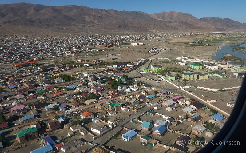
The opportunities for retail therapy in Ulaanbaatar Airport’s domestic departure lounge are, to say the least, somewhat limited, but I do manage to negotiate purchase of a packet latte and use of the hot water boiler. The resultant drink is as white as snow, despite the packet confirming that it is at least intended to include coffee, but it’s sweet, wet and warm. The flight is very smooth. As we near the end I get a good aerial shot of a snow-covered mountain, not realising its significance for the day’s activities.
| Aerial view of Mount Tsambagarav(Show Details) |
Some cities are pretty close up even if they look disorganised from a distance. Ulgii belies the obvious nominative determinism by looking quite pretty as you fly in, courtesy of a mosaic of pastel-coloured tin roofs, but once you’re driving through it the old, decayed Soviet-era buildings and the massive amounts of new construction are both very visible.
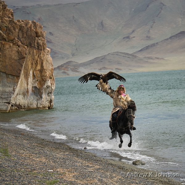
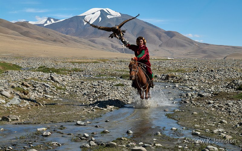
We check into our hotel, get a bite of breakfast, and then hit the road. We have a 2.5 hour drive south to meet a family of eagle hunters. Although nomadic, they are usually to be found in the shadow of Mount Tsambagarav, the same snow-covered (and very sacred) peak I had photographed from the plane.
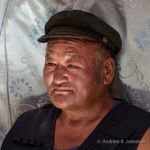
| Askhabyl Shaimurat, Eagle Hunter (Show Details) |
We have lunch with the head of the family, Askhabyl Shaimurat, who answers our questions about their life and the culture of the eagle hunters, and then after lunch we alternate between a couple of portrait set-ups, and photographing a couple of the more active hunters doing action shots, riding through water with their eagles. As the sun goes down we all move up hill to capture our new friends in environmental portraits lit by the evening glow.
| Eagle Hunter at Erget Gol (Show Details) |
| Eagle Hunter in front of Mount Tsambagarav (Show Details) |
We wait until sundown, and then it’s another 2.5 hours back to the hotel, which we reach near midnight, Ulaanbaatar time. It’s been a very long and action packed day, but full of wonderful photographic opportunities with a great family.
| Askhabyl Shaimurat, Eagle Hunter (Show Details) |
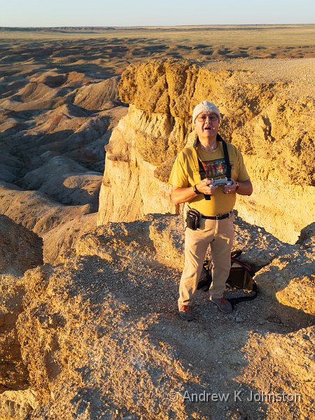
| Andrew at Tsagaan Survarga | |
| Camera: DJI FC3582 | Date: 28-07-2025 23:04 | Resolution: 2336 x 3114 | ISO: 140 | Exp. bias: 0 EV | Exp. Time: 1/640s | Aperture: 1.7 | Focal Length: 6.7mm (~24.0mm) | See map | |
See also the Iceland Camouflage Masterclass and Namib Desert Camouflage Masterclass
| Tsagaan Survarga | |
| Camera: DJI FC3582 | Date: 28-07-2025 22:46 | Resolution: 4032 x 2520 | ISO: 140 | Exp. bias: 0 EV | Exp. Time: 1/200s | Aperture: 1.7 | Focal Length: 6.7mm (~24.0mm) | See map | |
“‘Tis a custom more honoured in the breach than the observance”
Driving on the right in Mongolia…
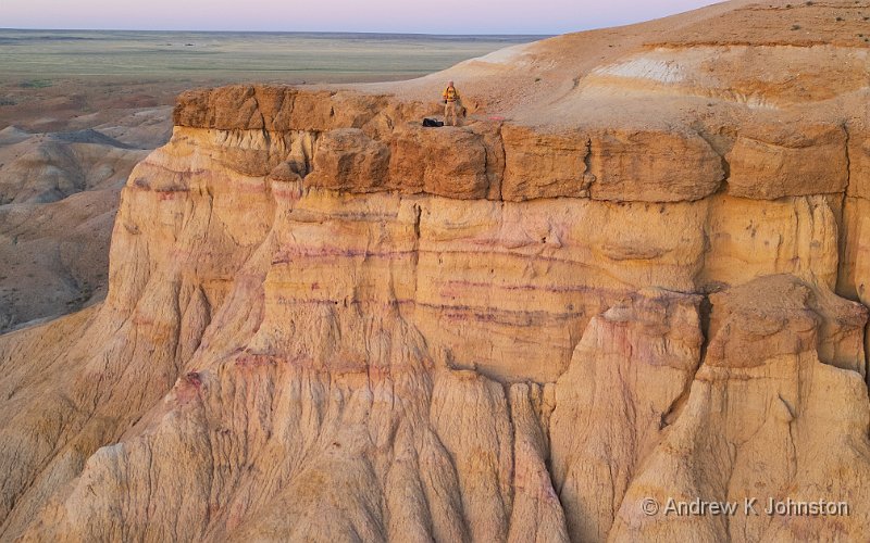
| Andrew in his Eyrie at Tsagaan Survarga (Show Details) |
After breakfast it’s back in the jeeps for the long drive back to Ulaanbaatar. I’d like to say the long relaxing drive back but that would be untrue. In addition to our driver’s habit of late breaking even when we can all clearly see a hazard, is his habit of ignoring the generally accepted convention that Mongolia drives on the right. I get that he has to not only overtake but sometimes move left to avoid a pothole, however he also frequently drives in the left lane for long stretches even when we can see distant oncoming traffic. The worst case is where he decides to do this going round a blind left-hand band in a clearly-marked “no overtaking” zone, for no apparent reason than he finds it more aesthetically pleasing…
We manage a coffee stop in what is rapidly becoming our favourite coffee shop in Mandalgovi, and then take lunch at the airport. This turns out not to be as daft as it sounds: the new airport is well-positioned about an hour out of the capital, there’s good parking, and Oyu has booked an excellent lunch at the Japanese Noodle Restaurant in the arrivals hall. The only problem is the usual one – the first course is generous, and then another, larger, course arrives!
After lunch we have the final short drive to the hotel, and a few hours to ourselves. However we have a long day tomorrow starting very early with an internal flight, so most of us spend the time repacking ready for that. An early, very light dinner and a few beers set us up for an early night.
[Technical note: I’m very pleased with my drone, the diminutive DJI Mini Pro 3 which seems highly capable despite its small size. However there’s a general problem with DJI RAW files – Capture One and some other common RAW processors don’t support them. The In-camera JPEGs are good, and I’ve used them for this blog, but it looks like getting a good generic solution integrated with my existing workflow and at acceptable cost is going to be non-trivial. I’ll write more on this if/when I find an answer.]
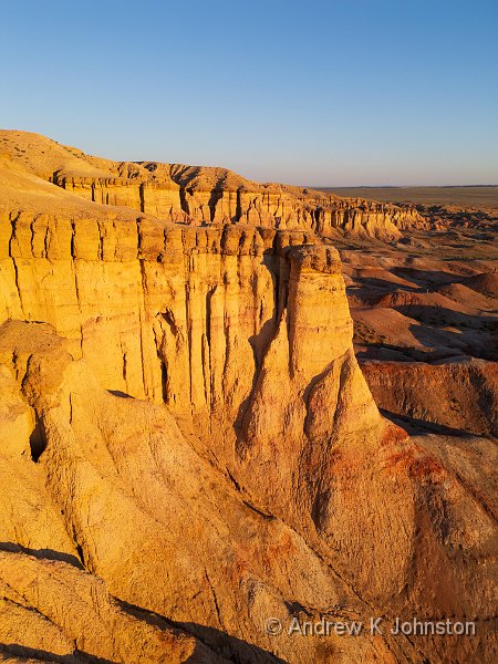
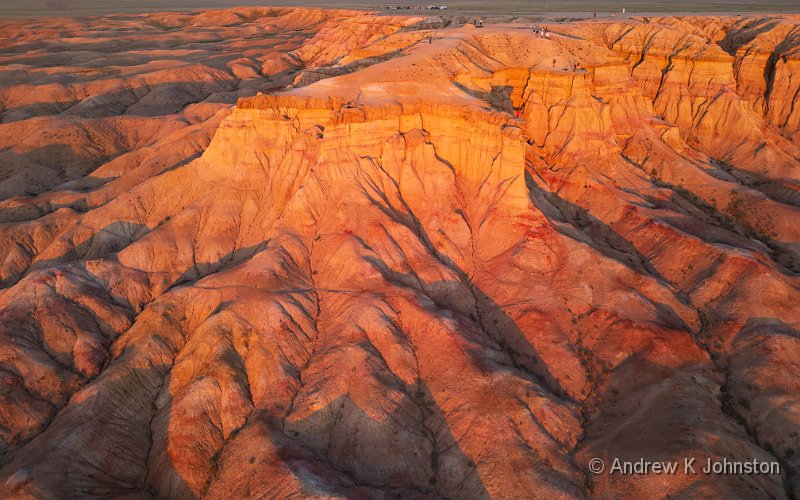
| Tsagaan Survarga (Show Details) |
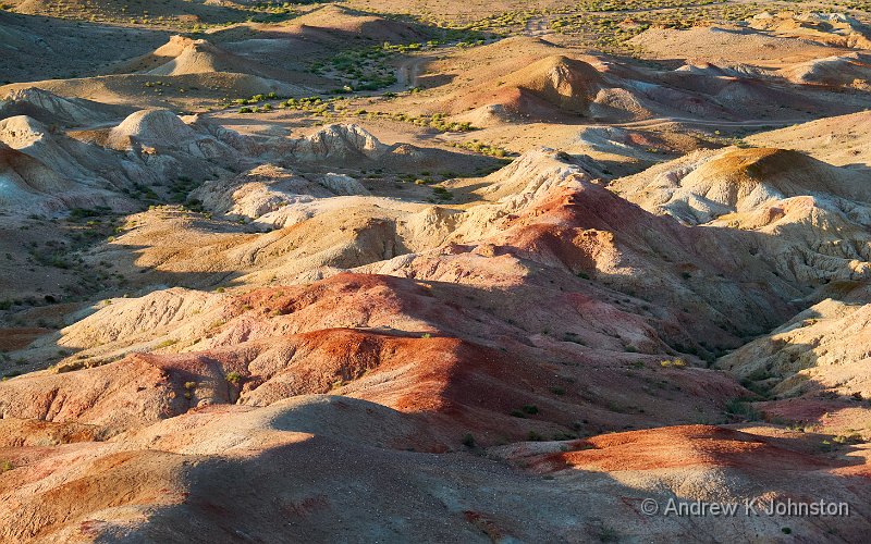
| Tsagaan Survarga | |
| Camera: Panasonic DC-G9M2 | Date: 28-07-2025 19:38 | Resolution: 5832 x 3645 | ISO: 500 | Exp. bias: 0 EV | Exp. Time: 1/160s | Aperture: 6.3 | Focal Length: 75.0mm (~163.0mm) | Location: Tsagaan Survarga | State/Province: Bilüünii Hural, Middle Govĭ | See map | Lens: LUMIX G VARIO 35-100/F2.8II | |
With my digestive system playing fairly nicely I decide to join the morning shoot. Rendezvous time is set for 5.15. At 5.14 I walk into the car park as fast as my little legs, dodgy knees and metal hip will carry me, to see the jeeps pulling out! I have to wave dramatically to flag one down and get in. I know Lee’s trips don’t follow US Ranger principles, but this is a new extreme.
I needn’t have bothered. When we get to the location it’s blowing a gale, whipping up sand all around, and the light is very poor. Mike has his cameras protected by plastic bags and puts them down for a minute, and by the time he picks them up they are already covered in sand. We cut our losses, thank our models (at least the human ones), and head back to breakfast.
After breakfast we pack up and set out on the first stage of the long drive back, which we plan to break near the canyon at Tsagaan Survarga.
Lunch is taken at a Korean restaurant where for the first time in the trip we are met by customer-facing staff who have both very limited English and non-existent customer-handling skills. I get a beer, but the girl on the till is unable to either make the right amount from the various notes I offer, or make change, or explain the problem. Eventually one of the guides has to bale me out and I pay with a card, but then have to persuade the girl to return the correct notes I already passed her. I’m sure there’s no intent – the Mongolians I have met are all scrupulously accurate and polite in their dealings with me – but it does suggest that the restaurant needs to work on their staffing policies. On a positive note the soup I have ordered is tasty, but difficult to eat with chopsticks!
Another couple of hours brings us to the Gobi Caravanserai camp. The futuristic buildings are like something from a classic sci-fi movie set on Mars, and not unlike the Chilean observatory used as a location for Quantum of Solace. The new en-suite rooms are nicely appointed but there are no chairs and I am having to type this standing up and stabbing the keyboard like Rick Wakeman does, so that’s a few points on the clock…
The other big problem is that the newly-built rooms ("hereinafter referred to as ‘the ovens’, m’lud") have large glass windows and doors facing the sun for much of the day, but no A/C, no forced ventilation (e.g. a fan), and no means of natural ventilation such as an opening window. The only option is to open both the patio door facing the desert, and the main door facing the courtyard. Chance of invading creepie-crawlies 100%. Chance of invasion by something larger (e.g. curious camel, snake) non-zero.
There’s no WiFi in the rooms, and for the first time in the trip I don’t have a usable signal on my Mobicom Mongolian SIM. The bar beckons.
After an early dinner we head out to the canyon. Although these "badlands" are being bathed in beautiful late-evening light, they are almost impossible to shoot because of the force umpteen gale blasting up the canyon walls and across the top where we are trying to work. Regular readers will know how I boast of being able to hand-hold shots down to 1/5s, or even multiple seconds for wider angles. I’m struggling to get a usable shot at 1/500s, and all the while worrying about taking a tumble.
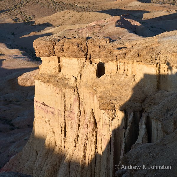
| Tsagaan Survarga (Show Details) |
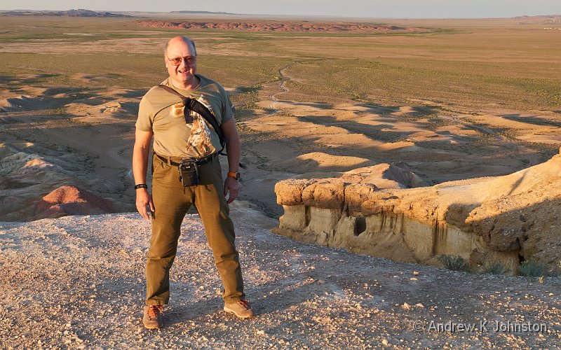
| Andrew atTsagaan Survarga (Show Details) |
As soon as the sun is down we head back to the hotel and sit outside waiting for the Milky Way, in the hope that at least an astrophotography opportunity might save the day. Sadly there is sufficient cloud that we’re unlikely to get a true and uninterrupted sky shot, but the conditions are sufficient to get a few memory shots. As I don’t have another model I opt for trying to get a "Milky Way Selfie". None is perfect (it’s really not that easy to run into position in less than 10s and then hold a pose for 20s), but I do get a couple of decent memory shots.
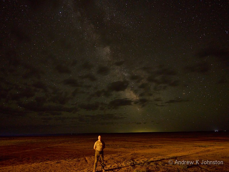
| The 20 second selfie! (Show Details) |
| Camels in the Khongor Dunes | |
| Camera: Panasonic DC-G9M2 | Date: 27-07-2025 05:58 | Resolution: 5491 x 3432 | ISO: 1250 | Exp. bias: -33/100 EV | Exp. Time: 1/125s | Aperture: 6.3 | Focal Length: 55.0mm (~119.0mm) | Location: Hongor�n Els | State/Province: Saynshand, �mn�gov? | See map | Lens: LUMIX G VARIO 35-100/F2.8II | |
The overnight power outage goes unnoticed, but I have a rough night courtesy of a howling wind and unexpectedly high temperatures. Having suffered with the cold mornings in Zimanga I have brought all sorts of cold weather gear for our dawn shoots, but the day dawns with the Gobi Desert at 26C. I don a T shirt, and suspect I have wasted half my luggage allowance. Sod it.
The dawn shoot echoes the evening one. We have the same herders (and quite possibly the same "lead" camels) in a slightly different location the highlight of which is that 4 out of 5 Land Cruisers get stuck in the sand and have to be towed out. I get more great shots, especially with a great dawn breaking behind the models, but it’s very much an extension of the previous session.
| Camel in the Khongor Dunes (Show Details) |
| Descending Camel (Show Details) |
Back at the camp I am suddenly struck by what can most politely be described as "Khan’s Revenge", and have a difficult morning running frequently to the facilities. Fortunately things seem to settle down during the afternoon, but it’s all a bit ominous given the amount of driving and flying on coming days.
After lunch I have a kip, and then plan to catch up with the blog. However I’m stymied by yet another power failure. I have internet access courtesy of a local SIM (which if I understood correctly gives me 15GB for about £4), but no power to the PC. Oh well.
I decide that discretion is the better part of valour and opt out of the sunset shoot, which based on weather conditions looks like becoming an extension of the previous two. The night has also been tagged for possible astro shots, but with heavy cloud cover that looks increasingly unlikely. I therefore hide in the bar, waiting for power to be restored, and am rewarded with a cut-price beer because the lad behind the bar has opened one too many, and selling it to me half-price is the easiest way to sort out the stock position. Excellent!
| Camels in the Khongor Dunes (Show Details) |
| Camels on the Khongor Dunes | |
| Camera: Panasonic DC-G9M2 | Date: 26-07-2025 19:23 | Resolution: 5525 x 3453 | ISO: 500 | Exp. bias: -33/100 EV | Exp. Time: 1/250s | Aperture: 7.1 | Focal Length: 100.0mm (~207.0mm) | Location: Hongorïn Els | State/Province: Saynshand, Ömnögovĭ | See map | Lens: LUMIX G VARIO 35-100/F2.8II | |
Day 3 is mainly a long drive south, to not far off the Chinese border. Thanks to the emergency replan this is a bit longer than expected, and we’ll also have a slightly longer drive back on day 5 returning to Ulaanbaatar from a more southerly site, but at least Mongolia has maintained its reputation for hospitality and kept a roof over our heads each night!
The main road south varies dramatically in quality and condition from place to place. After, say, 10 miles driving uninterrupted at UK motorway speeds you reach a section where the drivers have to pick their way around potholes almost deep enough to swallow a Land Cruiser. We make good time, but perhaps still less than the original plan allowed for.
Lunch is taken at the rather magnificent Grand Gobi Resort in Dalandzadgad. This combination of hotel, restaurant and night-club is styled like an enormous ger, but inside dominated by a statue of Genghis Khan. The food is good, but the portions are ridiculous. After a hefty salad with camel meat which most of us assumed was "it", we are each presented with a plate of 6 meat-filled pastries (think Cornish Pasty or empanada). One might have worked, two would have been generous, three covering absolutely all bases… We’re all sad to see so much food go back to the kitchen, but the heartiest trencherman amongst us manages 3 1/2.
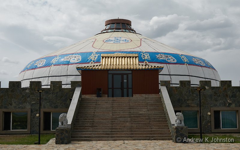
| Grand Gobi at Dalanzadgad (Show Details) |
The statue of Genghis Khan highlights an interesting problem. Most countries and their areas/cities can call upon a number of recognised cultural or historical figures to represent their image. Sometimes, as in Cuba in 2010, there is a conscious decision to limit things to a few chosen public figures. (They chose to iconise Fidel, Raoul and Che, but could have chosen from a range of musicians, sportsmen and gangsters!) However Mongolia’s interaction with the outside world is dominated by a certain 13th century warlord, and the outside world have few other references. He therefore dominates their imagery, but hopefully as Mongolia proceeds to make its own way outside the shadow of the Soviet Union we will start to recognise, and they will start to use, some other characters.
After lunch we head west from Dalandzadgad. The first 200km is on a very good new road and dispatched quickly, but then we turn off the surfaced road and head due north across country, through an impressive mountain valley, and reach the end of the Khongor sand dunes.
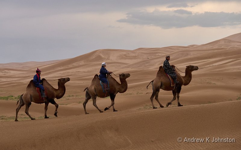
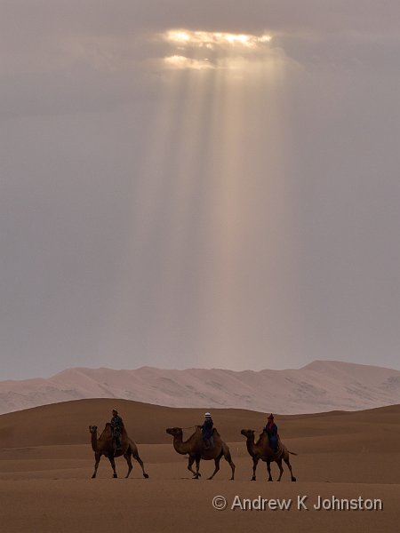
Before we reach the camp, we’re intercepted by a group of camel herders, who have been pressed into service to model for us as we photograph the camels and dunes. The sky is quite cloudy, providing less than ideal light to capture the dramatic scenery, but good light in which to do portraits of the herders and their animals.
| Camels on the Khongor Dunes (Show Details) |
After the shoot we do the final few miles to the Gobi Erdene camp. We’re each accommodated in a log cabin which is superficially attractive but scores very high on my Dysfunctional Hotel Room Design Index. [Update: the room not only scores a massive, unprecedented, 68 points, but has contributed 4 new categories!] Highlights include a single power socket positioned between the main and bathroom doors, but nowhere near any other surface, intermittent power which goes off during the night so nothing has charged, and a tap which is not actually screwed into the sink! Not impressed.
| Baga Gadzrïn Chuluu at sunset | |
| Camera: Panasonic DC-G9M2 | Date: 25-07-2025 20:32 | Resolution: 6198 x 3874 | ISO: 1250 | Exp. bias: -33/100 EV | Exp. Time: 1/60s | Aperture: 7.1 | Focal Length: 12.0mm (~26.0mm) | See map | Lens: LUMIX G VARIO 12-35/F2.8II | |
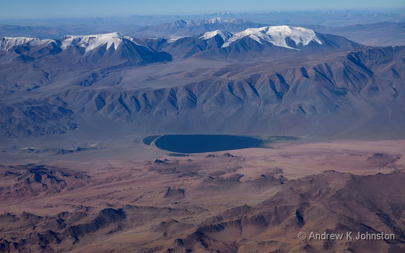
The big problem with Mongolia is that it’s so big. Big and empty. The distances between points of interest are usually several hundred km, there are few internal flights and a limited rail network. To explore multiple tourist destinations you are going to spend a lot of time on the road, and only a proportion of that will be on surfaced main roads.
On our second day we are therefore collected from the hotel by a convoy of five Toyota Land Cruisers, and set off on our long drive south. The jeeps are numbered, and to avoid any losses the drivers are determined to keep a tight convoy, in correct sequence, while making rather better progress than the official speed limit prescribes.
The resulting driving style can most politely be described as "enthusiastic", although we also exchange less printable terms. The drivers regard speed limits as non-applicable guidelines and no overtaking zones as vague suggestions. High speed progress is regularly interrupted by last-second braking and swerving to avoid potholes or crossing livestock.
Things are not helped by limited communication, even though each vehicle has a walkie-talkie. Following several near misses where our driver fails to brake quickly enough in response to brake lights in front, our jeep 4 is nearly into the back of jeep 3 during a more sudden than expected, unannounced, turn off the road to visit a family of horse breeders.
Sadly most of the horses are tied or corralled together, and difficult to photograph, but we do get some shots of the young lads riding bareback. However the family’s hospitality is unimpeachable, they welcome us into their ger and are happy to pose for portraits, although I decline the offer of fermented horse’s milk…
| Uncle of the horse-breeding family (Show Details) |
As we are getting back into the jeeps there is a more sudden than expected discovery that there’s been a cock-up on the accommodation front, and the camp we thought were expecting us for the night are not actually expecting us for four days. Fortunately the camp we had planned for the fifth night has space tonight, so the replanning is minimal, but it does mean turning tail and driving 100km back towards Ulaanbaatar, before we strike left on a rough trail to the revised location.
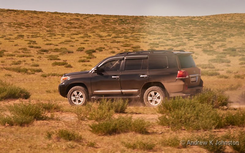
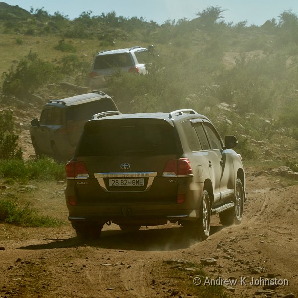
As per the highway speed limits, the drivers regard the unpaved routes as guidelines, and frequently strike out across unmarked terrain, or take multiple parallel routes to avoid being in each other’s dust trails. However the speeds are lower, separation a bit better and the surprisingly smooth progress is an impressive demonstration of just how good the suspension of a modern SUV can be when being put through its paces. Then, when more suddenly than expected the flat terrain turns into a steep climb up a narrow, rocky channel, you realise the Land Cruisers are in their element.
| Land Cruiser making pace through the steppe (Show Details) |
| Some serious off-roading (Show Details) |
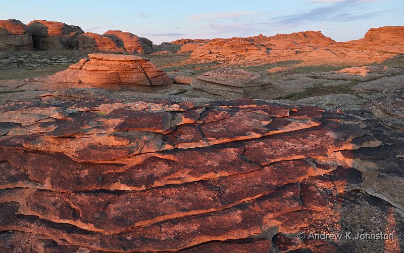
Although we arrive later than planned (the drive from the horse breeders has taken nearer 3 hours than the promised 1.5) we make arrangements to go and get some sunset photographs at the dramatic granite formations of Baga Gadzrïn Chuluu. This turns into an excellent 2 hours photographing the rocks in sunset light by camera and drone. This is the first time I have used my drone "in anger" as a mobile camera platform. The only challenge is working out which drone is whose, when you have all six in the sky.

| Baga Gadzrïn Chuluu rocks – drone shot (Show Details) |
A great end to a day filled with both the right and wrong sorts of excitement.
| Flying into Istanbul | |
| Camera: SONY DSC-RX100M7 | Date: 23-07-2025 11:38 | Resolution: 5472 x 3420 | ISO: 100 | Exp. bias: -0.7 EV | Exp. Time: 1/2000s | Aperture: 4.0 | Focal Length: 19.8mm (~54.0mm) | |
“Alright, alright, alright alright alright”. If you know, you know. If you have to Google it, it’s option 2!
At Terminal 2 Heathrow and the airlines seem to be running a massive social experiment on whether you can run airline operations with no visible staff and no support for customers if things are not going smoothly. The answer, which I could have predicted without experiment is clearly “yes, if volumes are relatively low and everything is working. Otherwise no.” By the time I get near the bag drop machines it’s complete Bedlam, with significant risk of a punch-up. Every case of “the computer says ‘no'” causes a complete breakdown, with no effective help to resolve things.
Fortunately I do eventually get to a machine which works for me, Security is very efficient, and I’m through quickly enough to have another short wait before breakfast is available. Full English downed, I feel more human. Once the rest of the group are also through we catch up before going to the gate. There a similar problem occurs: there’s no document check before we sit down, and Turkish Airlines then insist in doing the check before admitting you to the final boarding queue. There’s also no attempt to manage people coming forward by seat row or equivalent. The result is another massive and fragmented queue filling the gate concourse, and a pretty random arrival at the plane.
If this was a one off it would be bad enough, but the causes are so systematic you suspect it recurs on a regular basis, any time the early flight is fairly full. That they judge this acceptable is poor, especially when some simple steps could alleviate it, for example an email saying simply “if you are on the 6.30 please note check-in does not open until 4.00”. Very annoying.
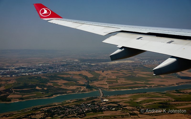
On a positive note the flight is smooth and quick, making up a near 1 hr departure delay, although once we are on the ground in Istanbul taxiing to the gate takes well over 20 minutes!
Istanbul Airport is new, spacious and comfortable. It’s also unbelievably, eye-wateringly expensive. A large latte is €9.50. A sandwich €15. After a couple of hours Lee and I decide we need a change of scenery and fancy a beer, but make the mistake of committing to an order before understanding the prices. A 500ml Efes beer, brought from Turkey to the UK, costs about £6 at our favourite Turkish restaurant in Epsom. At Istanbul Airport it’s over €18. That’s at least twice Copenhagen prices…
To add insult to injury, the “other half” of the group, those wealthy enough to be enjoying the business lounge, are providing a running commentary on WhatsApp regarding the food, the refreshing showers, the softness of the sheets in the private suites, and whether the space is large enough to explore using a drone rather than on foot.
My revenge will be terrible, and served cold…
At the gate for the Ulaanbaatar flight, there’s another repeat of the queuing fiasco. The only good thing is I have carefully positioned myself and am in the first group on. Turkish Airlines obviously judge chaos acceptable. I can’t work out whether this is cultural, due to a lack of staff with good English, or that good staff have simply given up struggling with the systematic issues.
Another smooth flight delivers us early to Ulaanbaatar, although due to some odd lighting choices in the Economy cabin I get very little sleep. Mongolian formalities are commendably quick, but I have a long wait for my luggage, which seems to be following a “first on, last off” rule. The transfer into town takes an hour, plodding through the notorious Ulaanbaatar traffic, but eventually we reach the hotel, and I can finally get some kip.
Sadly the WiFi doesn’t work in my room, so after a couple of hours sleep I decamp to the bar to get comms (good word for it🍺🍻)!
Hopefully more photos next time!
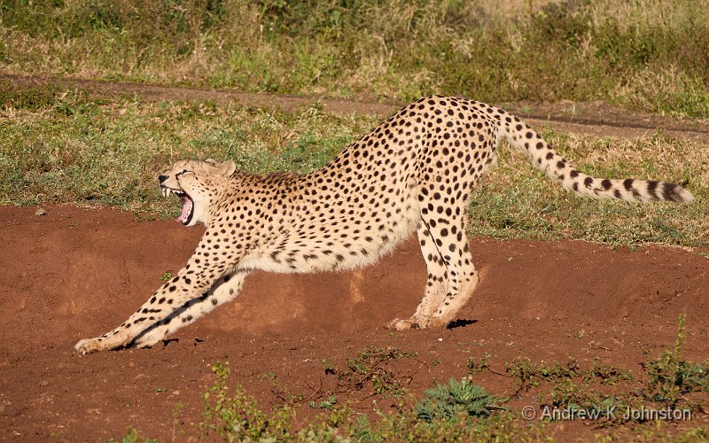
| Cheetah yawning, Zaminga | |
| Camera: Panasonic DC-G9M2 | Date: 12-06-2025 07:36 | Resolution: 5315 x 3322 | ISO: 160 | Exp. bias: 0 EV | Exp. Time: 1/320s | Aperture: 7.1 | Focal Length: 146.0mm (~292.0mm) | Location: Zaminga | State/Province: Thembalethu, KwaZulu-Natal | See map | Lens: LEICA DG 100-400/F4.0-6.3 | |
It’s instructive to look back on my Zimanga trip, to review what worked, and what I might have done differently. If you’re planning a photo safari, you might find the following useful.
Firstly, I can’t praise strongly enough the owners and staff of Zimanga (https://zimanga.com/). The vision to dedicate 7000 hectares of land to a game reserve specifically set up for photographers has paid dividends. I know our group all enjoyed it thoroughly, and Lee is having no difficulty selling his trips a couple of years ahead, thanks in part to a lot of repeat business! The staff are all charming, knowledgeable and helpful, and go out of their way to make you feel welcome. Highly recommended.
I was very pleased with my kit choices. I agonised a bit about spending the money to supplement my perfectly good 100-300mm lens (200mm-600m equivalent) with a used Panasonic 100-400mm, but it paid off well. I regularly used both the extra reach (especially on the smaller birds) and the feature to limit focus to >5m (vital for shooting from behind glass but not implemented on the 100-300). I did experience the common complaint that the zoom control is a bit stiff and slow, so it may not work so well for sports, but for this trip it was ideal.
Of the 1220 shots I have retained on the PC for further processing, over 80% were shot with that lens. Around 15% were shot with the 35-100mm f/2.8, and almost all the remainder, only about 4%, with the 12-35mm f/2.8. I always carry spares, but I could have done this trip perfectly easily with just the three lenses, and I could have lived with the tiny kit lens for the "normal zoom".
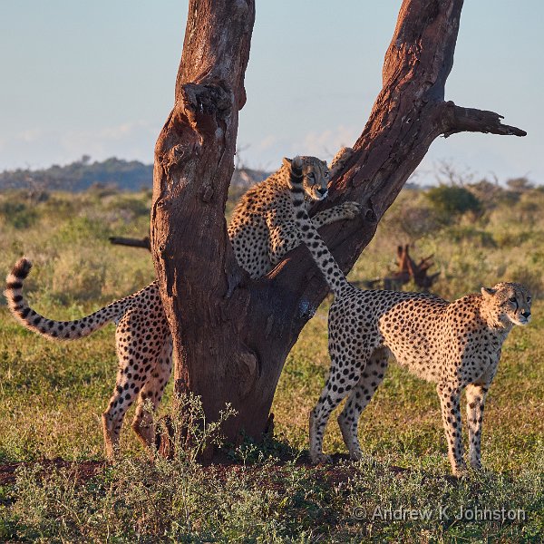
| Cheetahs playing, Zaminga (Show Details) |
My last-minute decision to trade in my old Panasonic GX8 for a used G9 also worked well. Because of the time pressure I just used the Wex Photographic used camera service for both the purchase and the trade-in, but it went like clockwork for a net cost under £150. Wex didn’t want the spare GX8 batteries but they sold almost immediately on eBay bringing the net cost under £100. For that I got a more modern camera which is similar enough to the G9 mark II you can switch quickly back and forth between them.
Don’t underestimate the number of shots you’ll take, or the storage requirement. My previous records were about 3300 shots over three weeks in the Desert Southwest of the USA, and 2900 shot over two weeks in Namibia (which combined wildlife, landscape and human subjects). In effectively 8 days in South Africa I took 6194 shots, and filled around 300GB of fast SD cards. After filtering I deleted about 100GB and moved over 130GB to my "unused image" archive disk, but I still have ~50GB (1220 images) to process further.
| The tail piece, Zaminga (Show Details) |
The other things you need are patience, and luck. Even with hides carefully designed to attract the animals, and dedicated guides constantly sharing information about what’s where, there was a lot of sitting around waiting, or driving across the reserve only to find the subjects had moved on. If you want the predictability of knowing for certain what you’ll see in a certain session, then maybe a trip to Longleat is in order!
I suspect that I lack the patience to do a lot of wildlife photography. I certainly missed a couple of hide shots because I was doing something else when the animal appeared. So be it.
Even with that caveat, I came away with a good collection of images, with some of which I’m extremely pleased. This was a very successful trip, and I can recommend it should you get the opportunity.
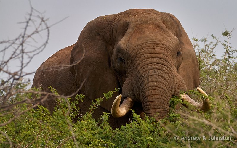
| Elephant, eating, Zaminga (Show Details) |
 Email me
 Others
 Main feed (direct XML)