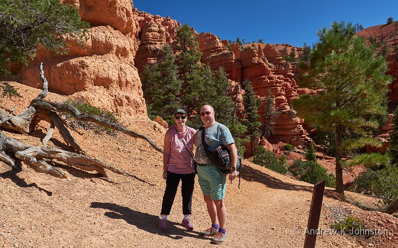
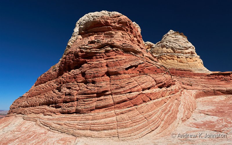
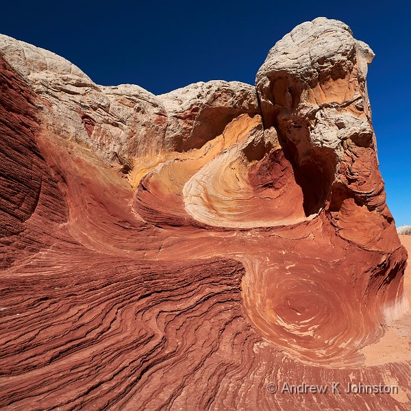
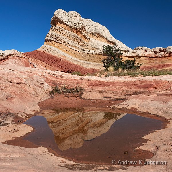
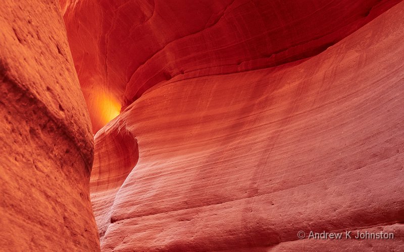
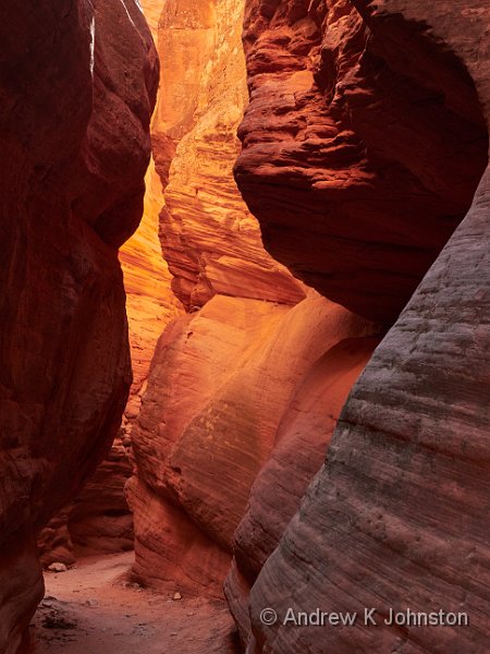
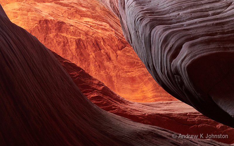
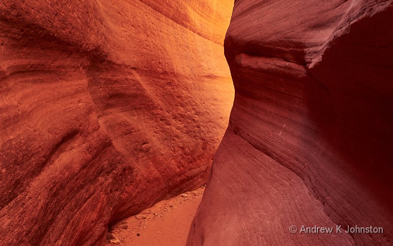
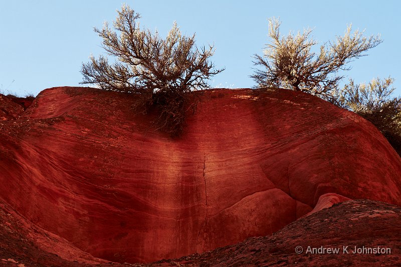
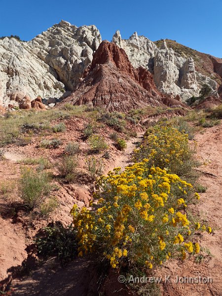
Author Archives: Andrew

In Which Andrew and Frances Solve the Problem of Food in the Grand Canyon

Sunrise at Yaki Point
Camera: Panasonic DC-G9 | Date: 03-10-2023 07:33 | Resolution: 5189 x 3243 | ISO: 800 | Exp. bias: -66/100 EV | Exp. Time: 1/60s | Aperture: 6.3 | Focal Length: 24.0mm | Location: Yaki Point | State/Province: Grand Canyon, Coconino, Arizona | See map | Lens: LUMIX G VARIO 12-35/F2.8II

Tuesday started with another dawn shoot. I caught the 5.30 shuttle bus to Yaki Point, which was full, but to my great surprise almost everyone got off at the prior stop, and I had the sunrise spot almost to myself. Initially I thought this might be a mistake caused by poor announcements on the bus, but the following day another possible explanation presented itself. Either way I got some great sunrise shots, in near solitude.

Sunrise at Yaki Point, with a fortuituous vapour trail (Show Details)

After breakfast we headed to the village, the old centre of Grand Canyon activities. Nowadays with the newest lodging and market a couple of miles away and the main visitor parking and visitor centre at twice that distance there’s no longer such a single focal point, but it’s still the start point for the shuttle-only Western Rim route.

We worked our way Westwards stopping at most of the viewpoints, ending up at Hermit’s Rest in nice time to have our picnic lunch. This was accompanied by a "hermit mocha", (coffee with some hot chocolate mixed in), but the latter was somewhat delayed by a camera crew who had temporarily taken over the cafe window and kitchen.

Pima Point (Show Details)

We then worked our way back through the viewpoints accessible Eastbound, but we were clearly going to be far too early at our target for sunset. We therefore stayed on the shuttle all the way back to the village, and went in search of a latte. We reached the cafe at the Bright Angel Lodge, and were shown to a table in an almost empty room and handed a dinner menu, at just before 3pm. We had broken the system! Not looking a gift horse in the mouth we ordered pulled pork and prime rib "sandwiches", wine and beer and had an excellent "tunch". The friendly young staff were lusting after our colourful clothing, so maybe we still have some style…

Appetite sated we got back on the bus to Hopi Point, and watched the sunset combined with photographing large raptors, eagles or maybe even Californian condors, and having a delightful chat with a retired American teacher.

Mohave Point (Show Details)

More like it.

Desert View Panorama (Show Details)
View featured image in Album
Posted in Travel, USA 2023 | Leave a comment

So Much for That

Desert View Watchtower
Camera: Panasonic DC-G9 | Date: 02-10-2023 12:56 | Resolution: 5247 x 2623 | ISO: 200 | Exp. bias: -233/100 EV | Exp. Time: 1/320s | Aperture: 7.1 | Focal Length: 12.0mm | Location: Desert View Watchtower | State/Province: Vista Encantada, Coconino, Arizo | See map | Lens: LUMIX G VARIO 12-35/F2.8II

The Jag-war is now officially an ‘Ag-war, the J having either detached itself from the boot-lid somewhere in the desert Southwest, or having been detached by someone else suffering from the aforementioned. ‘Opefully ‘Ertz understand.

I got up early and joined the crowd watching sunrise at Mather Point. The light was intermittent due to the heavy but broken cloud cover, but when it broke through we got nice splashes of colour on the rocks. It was bloody cold – even with my heaviest available hat and coat I was suffering a bit by the time the sun was fully up.

Mather Point Sunrise (Show Details)

Mather Point (Show Details)

After breakfast we set off back down the East Entrance Road to the Desert View area. This time the light was good and I managed to get up the Watchtower, a great brick folly on the wall of the Canyon with wonderful views outside and great recreations of native art inside.

Desert View Watchtower (Show Details)

At the next stop back towards the Lodge we were treated to a wonderful display, a rainbow forming underneath us, inside the Canyon.

Rainbow below Zuni Point (Show Details)

In the afternoon I took a sightseeing flight over the Canyon. We were a bit dubious of the safety record of the helicopter operator, so I opted for a fixed-wing flight. As a way of getting a fresh perspective it was fine, but as a photographic platform it was pretty useless, and I was battling a combination of odd angles and a dirty and scratched window. Next time I will be brave and stick to the helicopter.

Flight over Grand Canyon (Show Details)

After frankly disgusting food at Grand Canyon’s other outlets we had great hopes for our dinner booking at El Tovar, but we were sadly to be disappointed. Things didn’t start well – we arrived a few minutes early to be told our table was not yet ready, fair enough, and to come back nearer the exact time. We sat down about 5m from the person managing admissions. The next thing we knew I received a text, at international rates, saying the table was ready, only to be told again at the desk that it wasn’t.

We were eventually admitted, and shown to a cramped corner table with a view of the car park and a strong cold draught. The latter was so bad we eventually had to move ourselves. Our server turned up and was very helpful, but was unable to offer any alternative to sprouts as the vegetable accompaniment to roast duck! We tried to get on the Wi-Fi, but failed and the water boy appeared to take some delight in confirming that access was only available to residents, not restaurant customers.

The food was mixed: the soup, Elk Bolognese and the duck itself were good. The sprouts were like bullets and the rice pilaf was dry and inedible. Overall it was nowhere near the standard which should have been delivered for the very high prices being charged.

Back at the lodge we attempted to plan better catering for the next day, but literally every catering outlet in Grand Canyon Village and the gateway town of Tusayan gets, at best, very mixed reviews and many are downright appalling. The statistical distribution of TripAdvisor reviews is a whole topic for another blog, but we essentially gave up and decided to stick to sandwiches until we’re back in Utah.

Disappointed.

View featured image in Album
Posted in Travel, USA 2023 | Leave a comment

A New Nadir

Desert View, Grand Canyon
Camera: Panasonic DC-G9 | Date: 01-10-2023 16:53 | Resolution: 5184 x 3240 | ISO: 200 | Exp. bias: -33/100 EV | Exp. Time: 1/250s | Aperture: 6.3 | Focal Length: 35.0mm | Location: Desert View, Grand Canyon | State/Province: Vista Encantada, Coconino, Arizo | See map | Lens: LUMIX G VARIO 12-35/F2.8II

We got on the road early to drive down to the Grand Canyon. The first segment went very well, with a quick drive to Jacob’s Lake, a pleasant coffee and cookie stop, and some wonderful scenery in great broken light as we followed the 89A underneath the Vermilion Cliffs.

Vermillion Cliffs from Cliff Dwellers Lodge (Show Details)

That route ended at the Navajo Bridges. While these are still majestic with great views from the old bridge into the Colorado, they’ve changed the layout of the parking and viewing areas somewhat since our last visit in 2007 and I found it impossible to recreate my favourite shot with both bridges in the frame.

Vermillion Cliffs from Cliff Dwellers Lodge (Show Details)

Once over the bridge you are in the Navajo Nation, and there’s essentially nowhere for a stop until you reach Cameron, an hour down the road and only a mile before the turn off into the park. We were sufficiently desperate that we went into the Cameron "Trading Post" and opted for the "fine dining" option although we only really wanted a sandwich. Let’s put it this way: Michel Roux has nothing to worry about. Put another way, Frances described her toasted cheese sandwich as possibly the worst meal in recent record. My "chicken club" (burger) was marginally better, but came swamped by about 2000 calories of disgusting carbs. The main course was followed by a latte so strong Frances claimed she could taste it in her ears!

Lunch "dealt with" we drove into the park via the Eastern entrance which both saves about 100 miles driving and provides direct access to a number of viewpoints. At this point we encountered a new challenge – the temperature was dropping like a stone, and our "hot desert" outfits were woefully inadequate. I don’t think you can get pneumonia via the knees, but it’s just as well. That said the scenery was absolutely stunning, as ever, but between the temperature and tricky cloudy light we worked quickly and moved on promptly from each viewpoint.

Lipan Point, Grand Canyon (Show Details)

Once we’d booked into the Yavapai Lodge and settled into our room we went in search of sustenance. The Yavapai Tavern is a bit basic and produced a remarkably rubbery Elk burger, although for a change Frances’ chilli was OK. They do have one of the best beer menus I have seen in a long time, but that doesn’t fully compensate for an inedible meal.

Things can only get better. Tomorrow we’re on sarnies for breakfast and lunch, but we have dinner booked at the El Tovar restaurant. Fingers crossed!

View featured image in Album
Posted in Travel, USA 2023 | Leave a comment

To T’North (Rim)

Temple of Vishnu and Wotan's Throne from Cape Royal
Camera: Panasonic DC-G9 | Date: 29-09-2023 14:57 | Resolution: 9744 x 3058 | ISO: 400 | Exp. bias: 0 EV | Exp. Time: 1/500s | Aperture: 8.0 | Focal Length: 12.0mm | Location: Cape Royal | State/Province: Vista Encantada, Coconino, Arizo | Caption: Temple of Vishnu and Wotan's Throne | See map | Lens: LUMIX G VARIO 12-35/F2.8II

Kanab is probably the best base for a day trip to the Grand Canyon’s North Rim. We’ve had some aspiration to do such a trip since our first visit to the region in 1994, but each time it’s been prevented by the early closure of the North Rim after the first snowfall. Fortunately there was no such issue this time, and today we set off for our visit.

From Kanab it’s a very easy drive, albeit about 90 miles. The first section through Fredonia is a bit boring, but you have to watch the speed limits and Frances was battling with an odd road surface which while smooth had a pattern of shiny stripes reflecting the early morning sun. Fortunately the straight stretch quickly gives way to the climb onto the Kaibab Plateau, and the "almost mandatory" coffee and cookie stop at Jacob’s Lake provided for a quick recovery.

From there it’s a very pretty drive down to the North Rim, especially with the gathering Autumn colours, although you have to keep your eyes peeled. At one point we had to jam on the brakes to avoid a group of deer crossing the road, and the possibility of a bison or cattle encounter was signposted.

At the Rim our interaction with the Ranger at the visitor centre focused on the pending US government shutdown and the potential impact on the rest of our trip. However we decided not to worry about that, and had a nice walk around Bright Angel Point, followed by a picnic lunch.

The Temple of Vishnu (Show Details)

In the afternoon we drove the scenic drive down to Point Royal and back. This provides easy access to a range of the North Rim’s best viewpoints. It’s a very different experience to the south, where you’re looking across to the higher North Rim. Instead the Marble Plateau, itself at over 7000ft, stretches out below you. What is similar is that when you are on the road you can be 50m from the Grand Canyon, and be completely unaware it’s there.

We got back to Kanab a few minutes late for our dinner reservation, but needn’t have worried as unusually Adria’s was almost empty. However the food, beer and service were excellent and we’ve been promised live music for tomorrow, so we’ll pay them a repeat visit.

Minor Tribulations

We spent the morning on laundry and admin. The first source of minor panic was the near miss on the US Government shutdown. This might have significantly impacted our trip, although it appears that the governors of the states with multiple National Parks have got tired of the federal government screwing up a primary income stream at random intervals and now have appropriate Plans B in place. In the end the shutdown was narrowly averted, but one continues to be bemused by a system of government in which the three main legislative branches are frequently working to not only different but actively opposed agendas.

With CNN on in the background I was also trying to make sense of the position on our credit cards. In the old days every transaction generated either a paper or email receipt, but it’s suddenly a lot more complicated. Hotels and tour companies take part payment at booking and part later, but you don’t necessarily get details of the second charge. A lot of minor transactions don’t generate a receipt at all. To further complicate matters Kanab appears to be a wierd twilight zone where they don’t get chip & PIN and resort to swiping, signing and multiple random variants thereof.

Admin completed we visited the movie set museum, and set about trying to find a light lunch. Although it was still about a month from the end of the season, and all the hotels were full, almost all the coffee bars and cafes were shut. We settled for soup and a cheese sandwich at an odd vegetarian cafe, but something less dairy focused would have been better for my digestion.

The Rimrocks (Toadstool Hoodoos) (Show Details)

In the afternoon we did the drive to the Rimrock Hoodoos, also known as the Toadstools. These are set in a small plateau within a mile of the highway. Unfortunately it had clouded over and I was battling the light, but hopefully I have some workable shots. While she was waiting Frances was watching the activity of an enormous tarantula scuttling over the rocks, but sadly just as I got back to her some other tourists spooked it and it went to ground.

The Rimrocks (Toadstool Hoodoos) (Show Details)

We took dinner at Adria’s, accompanied by live music. The band insisted on starting by each playing their own solo compositions, and initially we thought we might be making an early exit, but eventually they all got on stage together and did a set of energetic crowd pleasers covering The Animals, Creedence Clearwater Revival and similar and a good time was had by all.

Cracking!

Adria’s, Kanab (Show Details)
View featured image in Album
Posted in Travel, USA 2023 | Leave a comment

White Pocket

White Pocket
Camera: Panasonic DC-G9 | Date: 28-09-2023 11:50 | Resolution: 5141 x 3213 | ISO: 200 | Exp. bias: -33/100 EV | Exp. Time: 1/1300s | Aperture: 6.3 | Focal Length: 17.0mm | Location: White Pocket | State/Province: One Mile, Coconino, Arizona | See map | Lens: LUMIX G VARIO 12-35/F2.8II

Everyone knows The Wave, that curling saddle of twisted colourful layers of rock, and everyone wants to get to The Wave, but access is strictly controlled via a tight lottery, and only a few pull it off. However the Coyote Buttes area contains several similar formations, for most of which access is still straightforward, and the best known is White Pocket.

White Pocket – Across The Wormhole (Show Details)

It’s another destination for which you need an appropriate vehicle and guide, and I had again signed up with Dreamland Safaris. When I arrived at their office I was somewhat surprised to find about 10 other punters all going to White Pocket in three separate jeeps, but it is their most popular tour. However this does suggest that some form of access limitation may be on the way.

The drive in takes about 2.5 hours, with paved road giving way to good unpaved road, giving way to rough unpaved road and finally thick, deep sand. Fortunately our guide Maddi made it look easy, but I suspect it really isn’t.

White Pocket (Show Details)

White Pocket is a big area, bigger than The Wave, covering about 7 square miles and a typical route taking in the well-known and most dramatic formations is a 2-3 mile hike/scramble of 3-4 hours, if you’ve got and are used to photographers, which fortunately Maddi was.

White Pocket (Show Details)

There’s no single signature formation like The Wave itself, although The Wormhole comes close, but instead you have a procession of impossible looking rock loops and swirls, and waves, linked by white "brain rock" which is very easy to walk on.

White Pocket – Into The Wormhole (Show Details)

My advice is simple: if you can do this, do it before it also becomes inaccessible to all but a lucky daily few.

Obligatory White Pocket reflection shot! (Show Details)
View featured image in Album
Posted in Travel, USA 2023 | Leave a comment

Peekaboo!

Peekaboo Canyon Kanab
Camera: Panasonic DC-G9 | Date: 27-09-2023 09:28 | Resolution: 5184 x 3240 | ISO: 1600 | Exp. bias: 0 EV | Exp. Time: 1/10s | Aperture: 7.1 | Focal Length: 35.0mm | Location: Peekaboo Canyon Kanab | State/Province: Mount Carmel Junction, Kane, Uta | See map | Lens: LUMIX G VARIO 12-35/F2.8II

On Wednesday morning I had another planned trip, to Peekaboo Slot Canyon near Kanab. This has many similar features to Antelope Canyon, except that if you time it right it’s completely empty, and a photographer can be left entirely to their own devices to play with equipment, settings and compositions as they wish.

Peekaboo Canyon Kanab (Show Details)

The big challenge is that the drive (or hike) in is over a mile of deep, soft sand, not to be attempted in a normal road car regardless of pedigree, so most people use the services of a specialist tour company, and I was no exception, going with Dreamland Safaris, a local company in Kanab. Our guide, Orion, was both an excellent driver and a highly entertaining guide, although I don’t think any of the guests managed to get a word in edgeways.

Peekaboo Canyon Kanab (Show Details)

The canyon lived up to its reputation, with great reflected light through the early morning, and I came away very happy with the results.

Peekaboo Canyon Kanab (Show Details)

Over lunch Frances and I realised that while Kanab and environs might fill four days, we didn’t want to return after Bryce Canyon, and felt a replan coming on, to make a different use of our last couple of days. Replan aside we had a quiet afternoon, fitting in a drive to the somewhat disappointing Johnson Canyon and some shopping before an early dinner.

Dinner itself was hilarious, including educating the waiter how to make an Irish coffee, and threatening him and the bartender with broken legs if they attempted to repeat the excess of their compatriot at Glacier National Park and add a nice bit of Crème de Menthe for a splash of Kelly Green.

Tomorrow I would be back to Dreamland Safaris and my trip to White Pocket!

Peekaboo Canyon Kanab (Show Details)
View featured image in Album
Posted in Travel, USA 2023 | Leave a comment

Cottonwood Canyon Road

Grosvenor Arch
Camera: Panasonic DC-G9 | Date: 26-09-2023 14:58 | Resolution: 5100 x 3188 | ISO: 200 | Exp. bias: -33/100 EV | Exp. Time: 1/500s | Aperture: 7.1 | Focal Length: 26.0mm | Location: Grosvenor Arch | State/Province: Henrieville, Garfield, Utah | See map | Lens: LUMIX G VARIO 12-35/F2.8II

After breakfast we set off for the drive back to Kanab. We shared the first two stages, over the mountain to Boulder and then down the SR12 to Cannonville. These were uneventful, except to note that the aspen trees which were green four days earlier were now almost all yellow, and a few were on the way to orange. It’s amazing how a few cold nights can bring on such a sudden and coordinated change.

At Cannonville we left the main road and set off down Cottonwood Canyon Road – a well maintained but unsurfaced road which cuts straight through the Paria Plateau to emerge halfway between Page and Kanab. Completing this road had been on my to-do list since originally planning the 2007 trip. It’s a dramatic road of constantly changing scenery and geology. However the highlight for me was definitely Grosvenor Arch, a dramatic bluff of yellow stone in the middle of nowhere, topped by an amazing arch structure. The Jag-war, with its Range Rover underpinnings, managed the drive without fault, but I certainly wouldn’t attempt it in something with two wheel drive.

Grosvenor Arch, traditional view (Show Details)

Grosvenor Arch, side view (Show Details)

The last few miles of the road are a bit boring and feel somewhat interminable, but we eventually emerged onto highway 89 and turned right for Kanab. The town is very spread out, with a road pattern which while it does follow the American grid system, seems to have somewhat arcane numbering, and as a result we couldn’t find our hotel. At one point we pulled in in front of the local school, and I attempted to work out what we should be doing. Unfortunately the downloaded maps on Gaia GPS, while they appear to map almost every rock in Utah, don’t have Kanab street names so that wasn’t much help.

Candyland, Cottonwood Canyon Road (Show Details)

Meanwhile Frances was sitting pointing at the big screen on the car’s dashboard, struggling for the right words. "That.. The magic machine… For Finding Places… Would that work?". After much hilarity we put the address into the Jag’s GPS and it took us directly to the hotel. Magic.

Dinner was somewhat delayed for various reasons. We were running late and most restaurants in Kanab had a queue. We got near to the front at one before realising that the primary ingredients in all their dishes were garlic and chilli. We were finally sat down with drinks and food ordered at the Iron Horse, and all the lights went out! The staff appeared completely unphased and just circulated with warm words until things went back on about 15 mins later. We were eventually fed and watered, but somewhat later than planned.

Candyland, Cottonwood Canyon Road (Show Details)
View featured image in Album
Posted in Travel, USA 2023 | Leave a comment

Jeepers!

Temple of the Moon
Camera: Panasonic DC-G9 | Date: 24-09-2023 18:39 | Resolution: 5917 x 3329 | ISO: 400 | Exp. bias: 0 EV | Exp. Time: 1/250s | Aperture: 8.0 | Focal Length: 12.0mm | Location: Temple of the Moon | State/Province: Capitol Reef NP, Utah | See map | Lens: LUMIX G VARIO 12-35/F2.8II

One of the reasons we have not previously explored Capitol Reef is that although it’s an enormous, diverse park, it’s not particularly well served by either self-drive roads or shared transport like a shuttle service. You can drive through the middle of it on highway 24, and up and down Scenic Drive and Capitol Gorge, and that’s about it.

In the morning we tried the Notom Road, which winds through a mix of public and private land on the East of the park. There are a few good views, but nothing that dramatic. Eventually the paved road gives out and rapidly deteriorates below a level we’re comfortable driving in a road car, even one with 4WD, and we returned to town.

That leaves the Cathedral Valley. This is home to some of Capitol Reef’s best known scenery, but even relatively optimistic guides like Martres make it clear that this is not for road cars or inexperienced off-road drivers. Good advice. I signed up for a jeep tour with one of the local specialists.

The full jeep tour, up the Lower Cathedral Valley and back through the upper part is not for the faint of heart, or the loose of fillings! It’s 58 miles of washboard, sand, deep dips, and the occasional segment where the road surface appears to be constructed mainly of pebbles the size of cricket balls.

Fortunately Backcountry Safaris had provided a Jeep Rubicon, and Alex a young lad who’s driving style on the highway was a bit disconcerting, but which came into its own as soon as we left it. Within 100 yards of the main road we descended a rough slope with about a 30% gradient, and then drove for some distance on the bed of the Fremont River, which brought back memories of getting stuck in a river in Iceland, but this time there was no such issue and the tour got started.

Cathedral Valley Trailhead, Capitol Reef (Show Details)

At the first stop we were somewhat surprised by a group of pretty ladies in nice dresses and inappropriate footwear – see if you can spot one in a pink dress below. Obviously one of the other tour operators does their photo tour with models. Maybe next time…

Bentonite Hills, Capitol Reef, with model! (Show Details)

The scenery is absolutely as dramatic as advertised, but the stretches between the landmarks were maybe longer than I expected. However that’s a small price to pay.

Jailhouse Rock Overlook (Show Details)

We did have a challenge with timing. Alex was obviously unused to dealing with photographers, and even with the best will in the world we probably spent more time at earlier stops than some tours. On top of that by the last week in September sunset at the Temples of the Sun and Moon is before 7. The result was a somewhat hair-raising dash to reach those final landmarks in the last of the golden hour sun, but we made it.

Overall an excellent experience, but I would advise others to discuss the timing of the trip with the outfitter, and maybe run a slightly earlier timeslot towards the end of the season.

Glass Mountain and Temple of the Moon (Show Details)

Sunset Point

We opted for another lazy morning. The reality is that magnificent as it is, unless you are going to do long hikes or drive off-road Capitol Reef only has accessible viewpoints and activities to fill two days. With the jeep tour done our remaining target was to witness a good sunset from Panorama and Sunset Points.

After breakfast we took a short drive which included the gift shop attached to one of Torrey’s camp sites. While not an obvious target there was just something about it which looked hopeful. 20 minutes later we emerged with three of my favourite Mountain t-shirts plus one for Frances, all in the end of season sale at an average price of about £12.

We had a leisurely couple of hours by the pool, then set off mid-afternoon for the final run through the park. This time the weather played ball. We found a couple of additional viewpoints on the Scenic Drive, then hit Panorama Point, The Goosenecks, and finally Sunset Point, timing our arrival almost perfectly.

Views from Sunset Point (Show Details)

Capitol Reef, done. Tick.

View featured image in Album
Posted in Photography, Travel, USA 2023 | Leave a comment

The Burr Trail and Into Capitol Reef

The Fluted Wall, Capitol Reef
Camera: Panasonic DC-G9 | Date: 23-09-2023 10:48 | Resolution: 11016 x 3597 | ISO: 400 | Exp. bias: 0 EV | Exp. Time: 1/500s | Aperture: 8.0 | Focal Length: 17.0mm | Location: The Fluted Wall, Capitol Reef | State/Province: Capitol Reef NP, Utah | See map | Lens: LUMIX G VARIO 12-35/F2.8II

For the next stage of our trip we had to move on from Escalante to Torrey, at the gateway to Capitol Reef National Park. First leg of the journey was along the dramatic stretch of Scenic Route 12 to Boulder, a road we have driven several times but never gets old. We stopped at the top of the Hog’s Back, the narrow ridge where the land falls several thousand feet both sides of the road, and I had yet another go at capturing it photographically.

In Boulder we found a great coffee shop apparently run by a retired member of the Village People – great coffee and croissants – then set off down the Burr Trail. This small but paved road eventually winds down to the bottom of Capitol Reef, but much of the photographic interest is in the first 25 miles. It starts with mounds of cross-bedded cream limestone, but then the road descends into the aptly-named Long Canyon. This runs for about 10 miles with the road winding along the bottom alongside the riverbed, red and grey canyon walls towering above.

Singing Canyon on Burr Trail (Show Details)

At one point there’s a short but dramatic slot canyon. It’s not Antelope Canyon, but it is pretty, a few feet from the road, and about a million less people.

Singing Canyon on Burr Trail (Show Details)

Burr Trail Overlook (Show Details)

Back in Boulder we revisited the coffee shop, then hit SR12 for the final run to Torrey. This section is different again, a pretty winding Alpine route with cattle grazing and aspens replacing the cottonwood trees – the pass summit is at 9600 feet.

We finally reached the end of the 12 at its junction with the 24 a few miles outside Capitol Reef. We took dinner at the local Mexican restaurant, which was absolutely buzzing. Frances took great delight in inspecting the comings and goings at the liquor store next door. Torrey is in a different county to Escalante and they obviously have a more relaxed attitude to booze. There’s even a distillery over the road!

Burr Trail Overlook (Show Details)

Desert and Oasis

The Red Sands Hotel in Torrey shows the downside of too much checking on TripAdvisor. The rooms are large and clean, but they are overpriced and poorly equipped and the hotel has no soul or view. Several impracticalities will get added to my list… A mile down the road we found my first choice: stunning views, cheaper and a very nice restaurant over the road – I might have compromised on the age of the bedding.

After a gentle start we set off to explore the park. Everywhere you turn there’s a new, dramatic vista with yet more forms and colours in the rocks. However it’s interesting just how much varies with the quality of the light, and the direction of travel. In 2007 we drove route 24 from East to West, in dull conditions, and didn’t get any of the majesty which hits you like a slap heading into the park from the West in good light.

In amongst the towering rocks and stretches of desert brush you have the Fruita Oasis, a small valley fed by the Fremont river which even at the end of a heatwave summer is pleasant and green. The original Mormon settlers moved on with the creation of the National Park, but the rich orchards still generate vast quantities of fruit available to visitors on a "U pick" basis.

Capitol Dome over Fremont River (Show Details)

In the afternoon we did the aptly named Scenic Drive including the short unpaved section into Capitol Gorge. The scenery was consistently stunning, but towards the end clouds were gathering and the dull light killed effective photography.

We therefore headed for an early dinner at the Rim Rock Restaurant. I ordered a coke to start, and a very small glass turned up. It took one sip to establish this was not just a coke, but had a substantial shot of rum in it. I know some of the Americans struggle a bit with my accent, but that’s a new one. Planned drink restored we had an excellent meal, albeit slightly interrupted when the last rays of the setting sun broke through the cloud lighting up the view with a stunning orange glow which sent everyone running for their cameras.

Here’s hoping for better light tomorrow.

View featured image in Album
Posted in Travel, USA 2023 | Leave a comment

Devil’s Garden and Hell’s Backbone

Devil's Garden
Camera: Panasonic DC-G9 | Date: 21-09-2023 18:14 | Resolution: 4824 x 3015 | ISO: 200 | Exp. bias: 0 EV | Exp. Time: 1/160s | Aperture: 7.1 | Focal Length: 19.0mm | Location: Devil's Garden | State/Province: Escalante, Garfield, Utah | See map | Lens: LUMIX G VARIO 12-35/F2.8II

Red Canyon

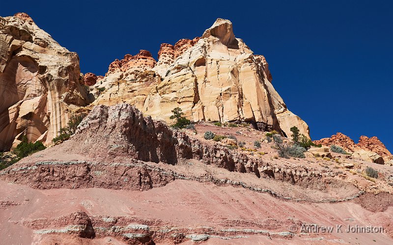
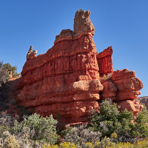
After a good stay at the Thunderbird Lodge we hit the road towards Escalante. The morning’s highlight was Red Canyon, a relatively small area with similar geology to Bryce, but many of the rocks are a bright reddish shade. Many of the best views are from the road or a short trail around the visitor centre. We’ve driven past previously without time to stop and explore, so we took our time today.

Red Canyon (Show Details)

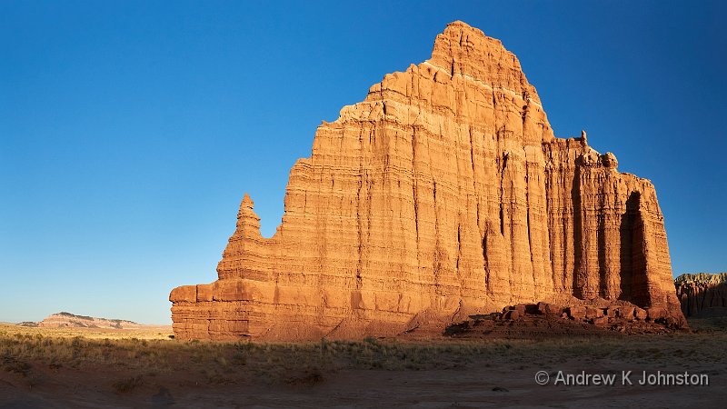
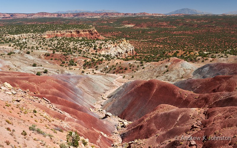
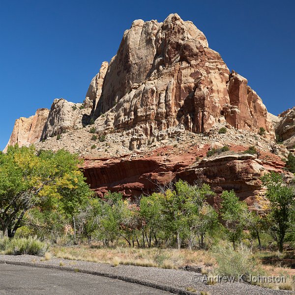
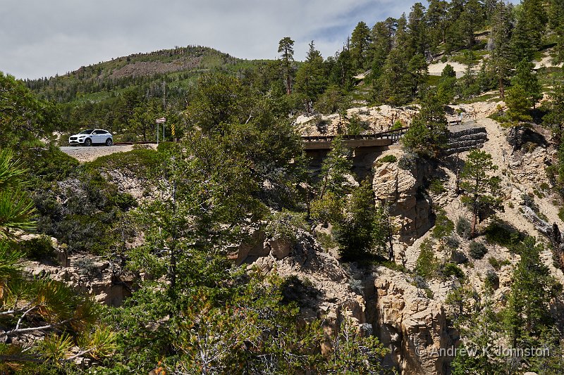
Scenic Route 12 is over 120 miles from its start near Red Canyon to its end at Capitol Reef, and a large number of those miles are packed with dramatic scenery. In addition the road has had a lot of work since our last visit and is now open, a comfortable width and beautifully surfaced. The drive to Escalante was a very pleasant one.

Red Canyon (Show Details)

The Canyon Country Lodge is a nice new hotel and we had a pleasant few hours in the sun. Dinner, however, was complicated by Utah’s licensing laws. We’d already fallen foul of the rule that you can’t order a drink until you’re sitting down with meal ordered, so you go thirsty if there’s a wait for a table. Tonight we had a new version: we sat down promptly, placed our food and drink order, and then they couldn’t find any staff over 21 to open the bottles and carry the drinks to our table, so the drinks only turned up with the last course, carried to the table by a suitably qualified (old) member of staff who looked suspiciously like the gardener. You also can’t finish drinks off outside the restaurant area, so the concept of a relaxing drink in the lounge doesn’t exist. Annoying.

Hell’s Backbone

After a disturbed night’s sleep (what idiot leaves the alarm set for midnight on a hotel room clock?) I did a solo dawn shoot at the Devil’s Garden. This was straightforward apart from the Jag-war’s satnav dumping me in the middle of nowhere 4 miles from target at which point I had to revert to manual navigation and dead reckoning. When I arrived the car park was occupied by several trucks with photographers milling around, but they promptly got into their trucks and drove off, not hanging around for the wonderful golden hour light. Odd.

Devil’s Garden (Show Details)

Back at the hotel we discovered that there is nowhere to get a decent breakfast in Escalante. Every shop, regardless of the nature of their merchandise, will sell you a coffee, but none of the cafes and restaurants do breakfast service. The fare on offer at our hotel was inedible, and the very nice diner attached to the motel where we stayed in 2007 seems to have disappeared.

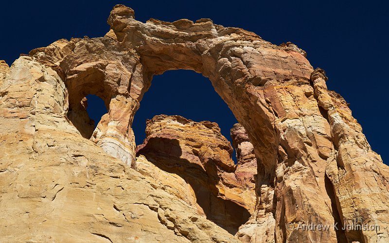
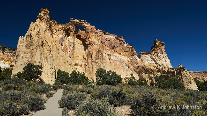
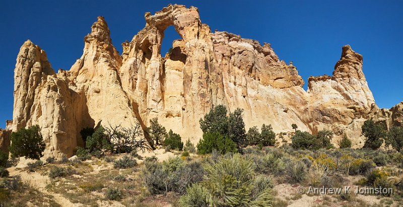
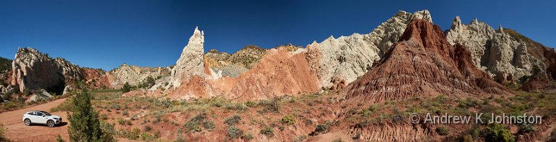
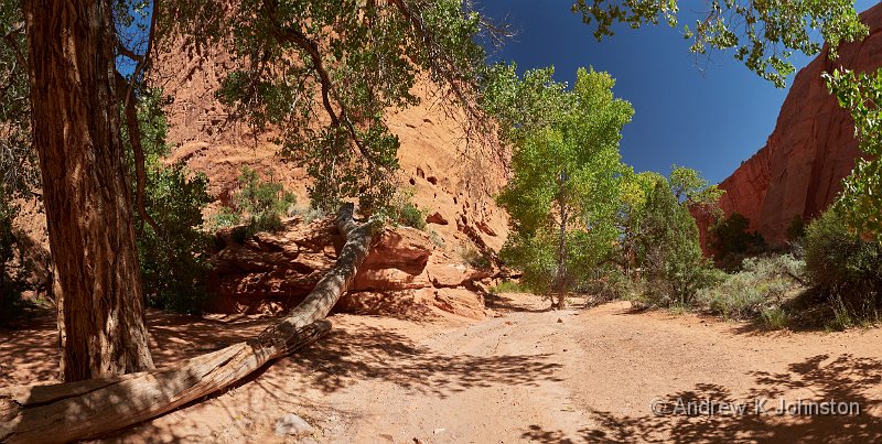
Mid-morning we set off on the aptly named Hell’s Backbone, a 38 mile high-country unpaved road between Escalante and Boulder, which was the only way to get between them until the challenging engineering of the new, lower road in the 1940s. Most of the drive is in forest, moderately demanding and not very interesting, until you reach Hell’s Backbone Bridge, a short and narrow link (109 ft long and 14 ft wide) between two outcrops. This apparently took about a day off the old horse trail, but it also has the most dramatic views down into the valleys on both sides of a narrow ridge, and for probably a good 40 miles in both directions.

Hell’s Backbone Bridge (Show Details)

After a relaxing few hours at the end of the day we took dinner at the pizzeria. New variant on the Utah licensing laws: I had to go to the counter to order Frances’ second glass of wine, but I am not allowed to carry it to the table on my own so the proprietor had to accompany me with one glass of wine, apologising as we went. Daft.

You Can’t Win Them All

We had another poor night’s sleep courtesy of a big unexplained thump around midnight and a recurring noise sounding like someone pulling a water tank around the car park. However we then slept a bit longer in the morning which may have helped reset our internal clocks a bit.

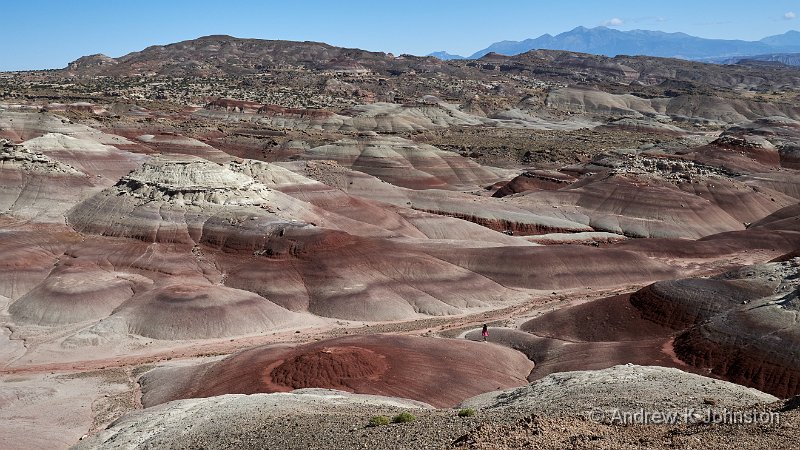
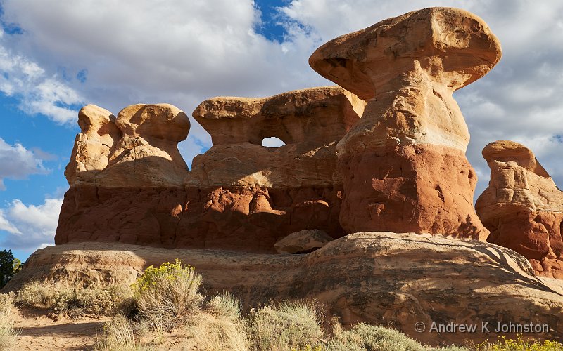
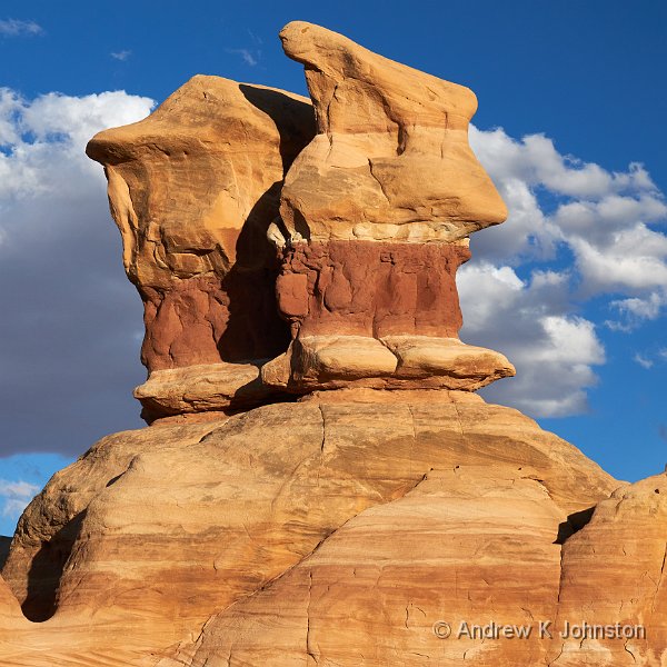
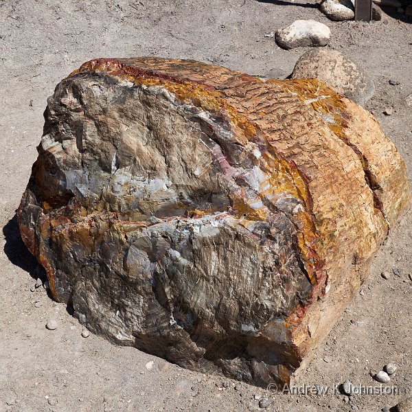
I took a walk round the Petrified Forest, which was a pleasant ramble but had only a couple of really dramatic pieces of fossilised wood, so I’m not sure "Forest" is fully justified.

Escalante Petrified Forest State Park (Show Details)

We took lunch at the deli, where delivery of our coffees was somewhat delayed by a rather public employee relations dispute. Not for nothing is the Chinese symbol for war two women under one roof. I suspect there may be a staffing change coming on, but it’s also possible they have been carrying on like that for years…

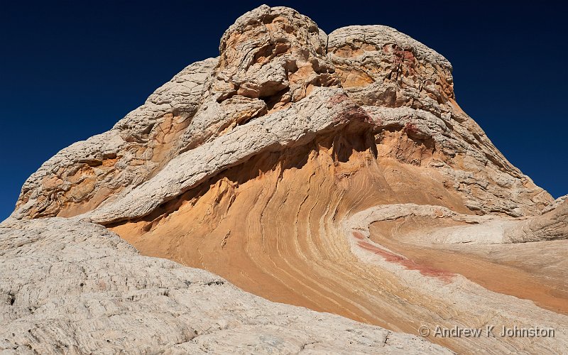
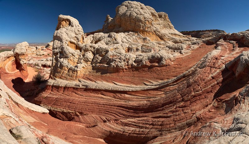
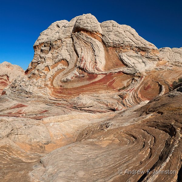
After a lazy afternoon in the sun we went back to The Devil’s Garden to photograph the rocks at sunset. Four miles from the site a large number of cars were parked up in the middle of nowhere roughly where the Jag-war’s satnav dumped me the other morning. We carried on to the actual location and had that wonderful place to ourselves. Are we growing a race who really cannot cope if the computer is wrong?

Back in town we took dinner at a different restaurant attached to another new motel. The food was delicious, service was prompt and they presented no complications due to Utah licensing laws. On the other hand it had absolutely zero ambience and the music was awful – weird covers of 60s hits. You can’t win them all.

Metate Arch, Devil’s Garden (Show Details)
View featured image in Album
Posted in Travel, USA 2023 | Leave a comment

Doing Zion Justice

View of East Zion
Camera: Panasonic DC-G9 | Date: 18-09-2023 16:00 | Resolution: 5612 x 3157 | ISO: 200 | Exp. bias: -33/100 EV | Exp. Time: 1/500s | Aperture: 7.1 | Focal Length: 12.0mm | Location: Views of East Zion | State/Province: Zion National Park, Utah | See map | Lens: LUMIX G VARIO 12-35/F2.8II

Not only a good night’s sleep but also an excellent breakfast turned out to be included in the $130 per night for the hotel in La Verkin, not quite sure how they pull that off. It does make a difference having a good start to the day.

We’ve visited Zion Canyon three times over 30 years, but previously always come away feeling underwhelmed. We therefore set off into the park with moderate expectations, but a bit more time to spend than under the original plan. First contact reinforced our concerns, as traffic was slow, parking difficult and purchasing our parks pass effectively impossible due to IT issues. We filled our water bottles and headed to the mandatory shuttle bus.

The drive up the valley teased with great views and I worked my techniques for photographing from inside a moving vehicle, however when we got to the end the river walk from the Temple of Sinawava was crowded and uninspiring. Fortunately things got better at the next stop, with a well-lit soaring vista to admire.

Once again Martres’ instructions paid dividends. He has assigned the name "Photo Point" to "40 feet below the unnamed car park between stops 8 and 7" and with good reason as you can get great compositions including both The Organ and The Great White Throne. I was battling flare due to the Sun’s position, but hopefully I have some rewarding shots.

View of The Organ and Great White Throne from Photo Point
(Show Details)

The Zion Lodge has a beer garden, in which you can buy a beer without falling foul of the complexity of Utah licensing laws, of which more later, so that’s icing on the scenery’s cake.

View of East Zion
(Show Details)

We drove out through the East Entrance. On previous visits we’ve never really been happy with the lighting on that scenery, but today even though the sun was still fairly high in a clear blue sky everything had a warm glow and we stopped for shots at each turnout.

We came away feeling that we’d finally done Zion justice. Maybe it just helps doing it as an early stop not one of the last on the traditional Grand Circle tour. You can’t escape the fact that it’s overcrowded, but get away from the fixed routes and it is a gem.

View of East Zion
(Show Details)
View featured image in Album
Posted in Travel, USA 2023 | Leave a comment

Are British Airways a Bus Company?

'Nuff said

Are British Airways an airline or a bus company? You’d hope the answer was evident from the name, but I’m beginning to have my doubts. I’ve just done an analysis of the flights I’ve taken with them from Heathrow since 2018:

Morocco 2018. This was so ridiculous it’s laughable, but with a dark shade because it was really quite a bad health and safety failure. We sat at the gate for the outgoing flight and they called us forward by "group number". Instead of going down the ramp to an aeroplane, we had to go down several flights of steps and outside, where a number of buses were waiting. We were directly randomly to buses with no attempt to keep the boarding groups even roughly together. After a long ride we arrived at the plane in the middle of a field, which had two sets of steps set up. One bus went to the front, another to the back. This resulted in people with seats at the back boarding from the front, while some with seats at the back were boarding from the back. "Punch up" doesn’t quite cover it, the average bar fight in a film is better organised. Fortunately we managed to sort ourselves out, but literally "nil points" to the useless BA organisation, and thank the stars that no-one suddenly needed medical attention or worse.

We had two short-haul BA flights in 2019, to Belfast and Copenhagen. I can’t remember either involving a bus, but maybe I’m blanking it out.

Patagonia 2023. After a 13 hour flight from Argentina the plane landed in a field, and was met by a bus. The ride back to the terminal took so long that I noted on my blog that I wasn’t sure whether we’d actually landed at Heathrow, or Northolt!

Belfast 2023. Our scheduled flight was cancelled, and we got bumped to one next morning. Having waited on the tarmac at Belfast for about an hour we got underway, only to land at Heathrow and sit on the tarmac again. Eventually we docked at a gate, and went up the ramp, to be directed down the stairs and out of the building onto a bus. This then drove us round from the "international" side of T5 to the domestic one, a trip which took about 20 mins, despite the fact you could probably walk it in about the same time.

Las Vegas 2023. After a 10 hour flight we parked in a field, to be discharged onto a bus. The ride to the terminal wasn’t quite so interminable as some of the others, but long enough.

4/6, maybe worse.

A few years ago a comedian, I think it might have been Michael Macintyre, lampooned as peculiarly British the phenomenon of the replacement bus service, as seen through the eyes of a foreign visitor:

"But I have ticket for train?"

"Get on the bus!"

I see that BA are honouring the "British" in their name by simply extending this pattern.

View featured image in Album
Posted in Humour, Thoughts on the World, Travel | Leave a comment